


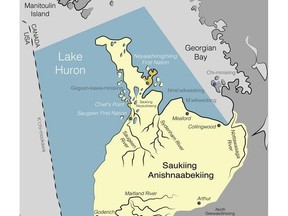
Saugeen and Nawash members are helping to create a map that shows how Saugeen Ojibway Nation people have used territorial lands and how much their lives are connected to the land and water.
“These maps are one of the strongest tools we can use in negotiations, court, and to protect our Territory from the impacts of development,” a summary of the project says.
Tobias & Associates, a research firm, has been hired to do the work. The company’s website says its work supports land claim negotiations, treaty litigation, environmental impact assessments and negotiations with industry.
SON Environmental Office information says there’s a $150 payment provided for participating. The office say personal information will remain confidential. Rides are available and mileage will be paid.
Participants will be invited to a celebration feast to receive their own personal map and to see the Territory maps that show everyone’s maps combined. Participants will help verify the maps created with the input from all participants.
“Help us protect our Territory from development and create an important record of the lifetime of use of living members,” the SON Environmental Office information says.
People conducting the survey interviews Sunday declined an interview request in the absence of permission from chief and council. Saugeen Chief Conrad Ritchie did not respond to an interview request Sunday.
More information is available at www.facebook.com/SaugeenOjibway.


