The ocean covers over 70 per cent of the Earth’s surface, yet we understand little about its geological structures. Less than 10 per cent of the ocean floor has been adequately mapped — leaving scientists with unanswered questions about the Earth’s processes and history.
The Benthic Ecosystem Mapping & Engagement (BEcoME) project is an OFI-supported research project led by Dalhousie and Memorial University. It aims to better understand the role of benthic habitats amidst the changing ocean climate.
To understand these ecosystems on the sea floor, scientists first need to know what the ecosystems look like by using innovative technologies to create maps of their physical features.
Mapping the ocean floor in Galápagos
To better understand the waters of a unique area in the Pacific Ocean, a team of OFI-supported marine scientists embarked on a research expedition to the Galápagos called Project Zombie. Throughout the five-week voyage, also supported by the Schmidt Ocean Institute (SOI), the team set out to collect data supporting the BEcoME project with new seafloor mapping technologies.
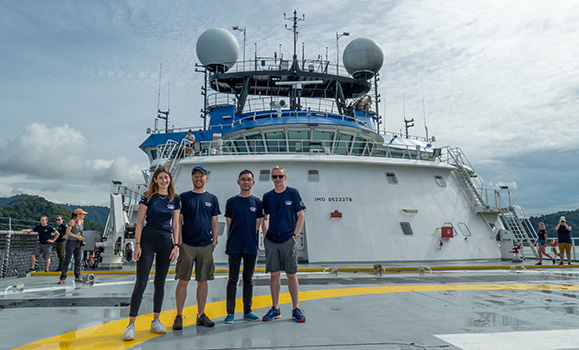
Aboard the Falkor (too) research vessel were 24 scientists from around the world, led by Chief Scientist Dr. John Jamieson from Memorial University and including BEcoME project co-lead Dr. Craig Brown from Dalhousie and PhD candidates Caroline Gini (MUN) and Jake Tan (Dalhousie).
Left to right: Caroline Gini, John Jamieson, Jake Tan, Craig Brown, the OFI-affiliated participants on the expedition. (John Jamieson photo)
The team was sent to test the capabilities of new imaging technology called Interferometric Synthetic Aperture Sonar (SAS) developed by Newfoundland-based Kraken Robotics. This seafloor mapping technology can generate both high-resolution acoustic images and bathymetric maps of the ocean floor. The technology is used in other offshore applications such as defense and offshore energy but had not previously been tested for its scientific applications.
“The OFI BEcoME project is pushing the boundaries of research by exploring and testing the application of some new mapping technologies. This SOI cruise was an exciting opportunity to install the latest mapping systems on a state-of-the-art deep-water submersible, and really put them through their paces in a deep water environment”, says Dr. Craig. “These areas had never been mapped before, and in addition to testing the technologies, the data led to the discovery of new hydrothermal vent systems”.
Underwater discoveries
“The success and efficiency of the high-resolution mapping and imaging for exploration, discovery and classification of the seafloor, as demonstrated by this project, is validation of importance of developing and testing new technology for understanding the benthic environment”, says Dr. Jamieson.
With the ease and precision of the InSAS technology, Dr. Jamieson and his crew returned to shore with many new and amazing findings.
The research team explored three hydrothermal vent fields north of the Galápagos Islands, including one field that was newly discovered on the expedition using the high-resolution mapping technology. The team promptly named this hydrothermal vent “Tortugas,” in reference to the famous turtles that are common in the waters around the islands.
Hydrothermal vents are found in association with submarine volcanoes along oceanic tectonic plate boundaries. Heat from magma beneath the seafloor causes seawater to circulate through the crust and form hot springs at the seafloor, where specially adapted underwater life can thrive. The vents are also known for being rich in valuable metals, and the expedition scientists are working to understand the formation and resource potential of these mineral deposits as well as the environmental risks associated with their potential exploitation.
During the expedition, the researchers further identified a pacific white skate nursery, only one of two documented globally, and 15 species of sea floor animals that were previously unknown to the area, some of which may be entirely new to science.
Mapping deep-water coral reefs in 3D
Dr. Katleen Robert from Memorial University’s Marine Institute, and the other BEcoME project co-lead, led a separate expedition on the Falkor (too) in the Galápagos ahead of Dr. Jamieson’s cruise also collecting data for the BEcoME project.
Dr. Robert and her team addressed another of the BEcoME project’s goals — mapping deep-water coral habitats in 3D.
The Galápagos Islands contain many deep-water cliff-dwelling coral reefs virtually unaffected by human impacts, and living under different environmental conditions. Expanding our understanding of cold-water corals across the globe is vital to predict how deep-water coral reefs are likely to change in the near future. Dr. Robert and her team utilised cutting edge Voyis Insight Micro laser scanner to create ultra-high resolution point-cloud reconstructions of these reefs—an achievement previously difficult to accomplish due to inadequate technologies.
SuBastian, the cutting edge remotely-operated vehicle (ROV) used on the expedition, is specifically designed for the deep sea. It can reach depths of up to four-thousand-five-hundred meters and was specifically outfitted with the laser system to collect data on reefs discovered at roughly 350 metres. This dataset will enable investigation of fine-scale relationships between habitat complexity and the organisms that inhabit these areas. Dr. Katleen Robert’s expedition retuned with great success, having discovered two deep-sea reefs. The reefs were booming with life, and the larger of the two spanned eight-hundred meters in length.
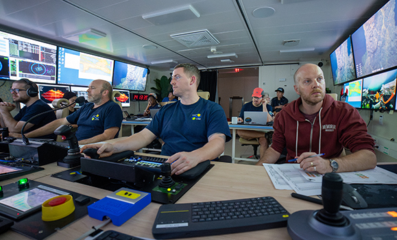
Dr. John Jamieson, centre, working in the ROV control room. (Schmidt Ocean Institute photo)
“We are thrilled our mapping data are able to improve our understanding of reef ecosystems in the Galápagos” says Dr. Robert. “The interdisciplinary science team is excited that the data collected during this expedition will contribute to growing knowledge on the Galápagos National Marine Reserve and contribute to the management of the Eastern Tropical Pacific Marine Corridor.”
The BEcoME project is continuing to work towards improving the collective understanding of the ocean floor via mapping to help facilitate future sustainable ocean stewardship.
With support from the Canada First Research Excellence Fund, Dalhousie is leading an ocean-first approach to tackle climate change and equipping Canada with the knowledge, innovations, and opportunities to secure a positive climate future. Our Transforming Climate Action series on Dal News spotlights some of the incredible work our researchers are doing in this area:
Comments
All comments require a name and email address. You may also choose to log-in using your preferred social network or register with Disqus, the software we use for our commenting system. Join the conversation, but keep it clean, stay on the topic and be brief. Read comments policy.
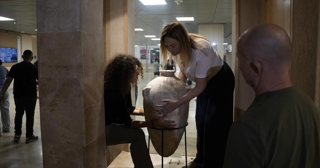
TEL AVIV, Israel (AP) — A rare Bronze-Era jar accidentally smashed by a 4-year-old visiting a museum was back on display Wednesday after restoration experts were able to carefully piece the artifact back together.
Last month, a family from northern Israel was visiting the museum when their youngest son tipped over the jar, which smashed into pieces.
Alex Geller, the boy’s father, said his son — the youngest of three — is exceptionally curious, and that the moment he heard the crash, “please let that not be my child” was the first thought that raced through his head.
The jar has been on display at the Hecht Museum in Haifa for 35 years. It was one of the only containers of its size and from that period still complete when it was discovered.
The Bronze Age jar is one of many artifacts exhibited out in the open, part of the Hecht Museum’s vision of letting visitors explore history without glass barriers, said Inbal Rivlin, the director of the museum, which is associated with Haifa University in northern Israel.
It was likely used to hold wine or oil, and dates back to between 2200 and 1500 B.C.
Rivlin and the museum decided to turn the moment, which captured international attention, into a teaching moment, inviting the Geller family back for a special visit and hands-on activity to illustrate the restoration process.
Rivlin added that the incident provided a welcome distraction from the ongoing war in Gaza. “Well, he’s just a kid. So I think that somehow it touches the heart of the people in Israel and around the world,“ said Rivlin.
Roee Shafir, a restoration expert at the museum, said the repairs would be fairly simple, as the pieces were from a single, complete jar. Archaeologists often face the more daunting task of sifting through piles of shards from multiple objects and trying to piece them together.
Experts used 3D technology, hi-resolution videos, and special glue to painstakingly reconstruct the large jar.
Less than two weeks after it broke, the jar went back on display at the museum. The gluing process left small hairline cracks, and a few pieces are missing, but the jar’s impressive size remains.
The only noticeable difference in the exhibit was a new sign reading “please don’t touch.”
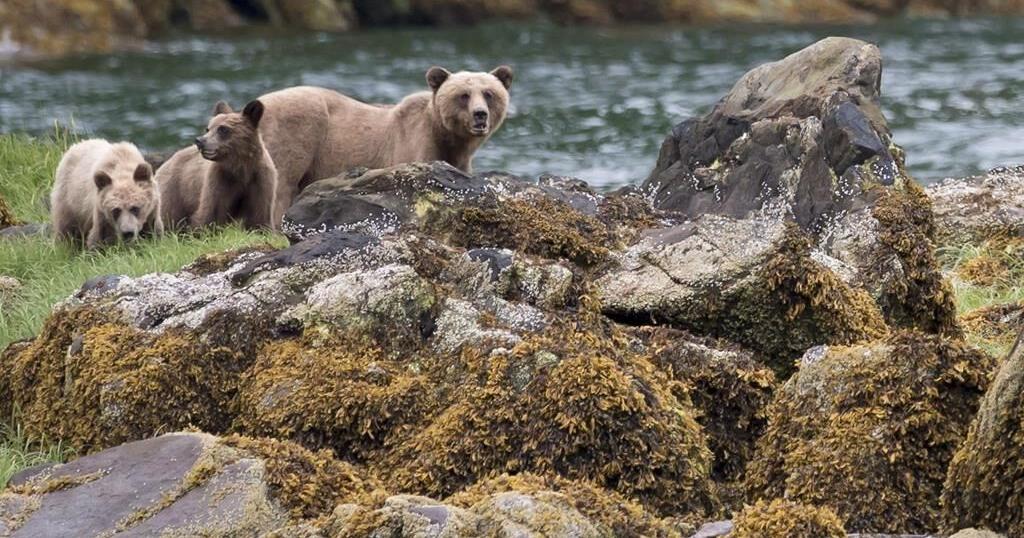
VICTORIA – The British Columbia government is partnering with a bear welfare group to reduce the number of bears being euthanized in the province.
Nicholas Scapillati, executive director of Grizzly Bear Foundation, said Monday that it comes after months-long discussions with the province on how to protect bears, with the goal to give the animals a “better and second chance at life in the wild.”
Scapillati said what’s exciting about the project is that the government is open to working with outside experts and the public.
“So, they’ll be working through Indigenous knowledge and scientific understanding, bringing in the latest techniques and training expertise from leading experts,” he said in an interview.
B.C. government data show conservation officers destroyed 603 black bears and 23 grizzly bears in 2023, while 154 black bears were killed by officers in the first six months of this year.
Scapillati said the group will publish a report with recommendations by next spring, while an independent oversight committee will be set up to review all bear encounters with conservation officers to provide advice to the government.
Environment Minister George Heyman said in a statement that they are looking for new ways to ensure conservation officers “have the trust of the communities they serve,” and the panel will make recommendations to enhance officer training and improve policies.
Lesley Fox, with the wildlife protection group The Fur-Bearers, said they’ve been calling for such a committee for decades.
“This move demonstrates the government is listening,” said Fox. “I suspect, because of the impending election, their listening skills are potentially a little sharper than they normally are.”
Fox said the partnership came from “a place of long frustration” as provincial conservation officers kill more than 500 black bears every year on average, and the public is “no longer tolerating this kind of approach.”
“I think that the conservation officer service and the B.C. government are aware they need to change, and certainly the public has been asking for it,” said Fox.
Fox said there’s a lot of optimism about the new partnership, but, as with any government, there will likely be a lot of red tape to get through.
“I think speed is going to be important, whether or not the committee has the ability to make change and make change relatively quickly without having to study an issue to death, ” said Fox.
This report by The Canadian Press was first published Sept. 9, 2024.
The European Space Agency is fast-tracking a new mission called Ramses, which will fly to near-Earth asteroid 99942 Apophis and join the space rock in 2029 when it comes very close to our planet — closer even than the region where geosynchronous satellites sit.
Ramses is short for Rapid Apophis Mission for Space Safety and, as its name suggests, is the next phase in humanity’s efforts to learn more about near-Earth asteroids (NEOs) and how we might deflect them should one ever be discovered on a collision course with planet Earth.
In order to launch in time to rendezvous with Apophis in February 2029, scientists at the European Space Agency have been given permission to start planning Ramses even before the multinational space agency officially adopts the mission. The sanctioning and appropriation of funding for the Ramses mission will hopefully take place at ESA’s Ministerial Council meeting (involving representatives from each of ESA’s member states) in November of 2025. To arrive at Apophis in February 2029, launch would have to take place in April 2028, the agency says.
This is a big deal because large asteroids don’t come this close to Earth very often. It is thus scientifically precious that, on April 13, 2029, Apophis will pass within 19,794 miles (31,860 kilometers) of Earth. For comparison, geosynchronous orbit is 22,236 miles (35,786 km) above Earth’s surface. Such close fly-bys by asteroids hundreds of meters across (Apophis is about 1,230 feet, or 375 meters, across) only occur on average once every 5,000 to 10,000 years. Miss this one, and we’ve got a long time to wait for the next.
When Apophis was discovered in 2004, it was for a short time the most dangerous asteroid known, being classified as having the potential to impact with Earth possibly in 2029, 2036, or 2068. Should an asteroid of its size strike Earth, it could gouge out a crater several kilometers across and devastate a country with shock waves, flash heating and earth tremors. If it crashed down in the ocean, it could send a towering tsunami to devastate coastlines in multiple countries.
Over time, as our knowledge of Apophis’ orbit became more refined, however, the risk of impact greatly went down. Radar observations of the asteroid in March of 2021 reduced the uncertainty in Apophis’ orbit from hundreds of kilometers to just a few kilometers, finally removing any lingering worries about an impact — at least for the next 100 years. (Beyond 100 years, asteroid orbits can become too unpredictable to plot with any accuracy, but there’s currently no suggestion that an impact will occur after 100 years.) So, Earth is expected to be perfectly safe in 2029 when Apophis comes through. Still, scientists want to see how Apophis responds by coming so close to Earth and entering our planet’s gravitational field.
Breaking space news, the latest updates on rocket launches, skywatching events and more!
“There is still so much we have yet to learn about asteroids but, until now, we have had to travel deep into the solar system to study them and perform experiments ourselves to interact with their surface,” said Patrick Michel, who is the Director of Research at CNRS at Observatoire de la Côte d’Azur in Nice, France, in a statement. “Nature is bringing one to us and conducting the experiment itself. All we need to do is watch as Apophis is stretched and squeezed by strong tidal forces that may trigger landslides and other disturbances and reveal new material from beneath the surface.”
The Goldstone radar’s imagery of asteroid 99942 Apophis as it made its closest approach to Earth, in March 2021. (Image credit: NASA/JPL–Caltech/NSF/AUI/GBO)
By arriving at Apophis before the asteroid’s close encounter with Earth, and sticking with it throughout the flyby and beyond, Ramses will be in prime position to conduct before-and-after surveys to see how Apophis reacts to Earth. By looking for disturbances Earth’s gravitational tidal forces trigger on the asteroid’s surface, Ramses will be able to learn about Apophis’ internal structure, density, porosity and composition, all of which are characteristics that we would need to first understand before considering how best to deflect a similar asteroid were one ever found to be on a collision course with our world.
Besides assisting in protecting Earth, learning about Apophis will give scientists further insights into how similar asteroids formed in the early solar system, and, in the process, how planets (including Earth) formed out of the same material.
One way we already know Earth will affect Apophis is by changing its orbit. Currently, Apophis is categorized as an Aten-type asteroid, which is what we call the class of near-Earth objects that have a shorter orbit around the sun than Earth does. Apophis currently gets as far as 0.92 astronomical units (137.6 million km, or 85.5 million miles) from the sun. However, our planet will give Apophis a gravitational nudge that will enlarge its orbit to 1.1 astronomical units (164.6 million km, or 102 million miles), such that its orbital period becomes longer than Earth’s.
It will then be classed as an Apollo-type asteroid.
Ramses won’t be alone in tracking Apophis. NASA has repurposed their OSIRIS-REx mission, which returned a sample from another near-Earth asteroid, 101955 Bennu, in 2023. However, the spacecraft, renamed OSIRIS-APEX (Apophis Explorer), won’t arrive at the asteroid until April 23, 2029, ten days after the close encounter with Earth. OSIRIS-APEX will initially perform a flyby of Apophis at a distance of about 2,500 miles (4,000 km) from the object, then return in June that year to settle into orbit around Apophis for an 18-month mission.
Related Stories:
Furthermore, the European Space Agency still plans on launching its Hera spacecraft in October 2024 to follow-up on the DART mission to the double asteroid Didymos and Dimorphos. DART impacted the latter in a test of kinetic impactor capabilities for potentially changing a hazardous asteroid’s orbit around our planet. Hera will survey the binary asteroid system and observe the crater made by DART’s sacrifice to gain a better understanding of Dimorphos’ structure and composition post-impact, so that we can place the results in context.
The more near-Earth asteroids like Dimorphos and Apophis that we study, the greater that context becomes. Perhaps, one day, the understanding that we have gained from these missions will indeed save our planet.


Read comments policy.