adplus-dvertising
Connect with us

Science

Re-entry of large Chinese rocket booster spotted over Borneo – Spaceflight Now – Spaceflight Now

Published

 on


EDITOR’S NOTE: Updated after confirmation of re-entry.

This map shows the location of the Long March 5B core stage’s re-entry over Borneo. Credit: Aerospace Corp. / Spaceflight Now

The 22-ton core stage of a Chinese rocket fell back to Earth Saturday, the third time in two years China has allowed such a large booster to re-enter the atmosphere uncontrolled. There were no immediate reports of wreckage or damage on the ground. Space debris experts said the unguided re-entry posed a low but avoidable risk to the world’s population.

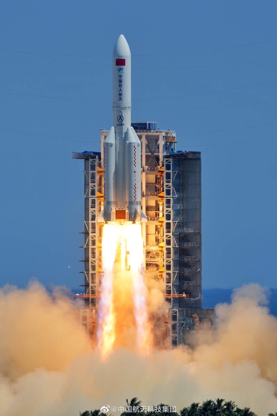
The Long March 5B rocket took off July 24 with the Wentian module for China’s Tiangong space station, hauling one of the heaviest payloads launched into orbit in recent years. The nearly 100-foot-long (30-meter) core stage of the Long March 5B rocket fired its two hydrogen-fueled engines for about eight minutes to inject the Wentian module into orbit.

300x250x1

Four strap-on boosters burned their propellant and jettisoned a few minutes after launch to fall into the South China Sea. But the design of the Long March 5B, one of the most powerful operational rockets in the world, means its core stage accelerates to orbital velocity.

Most launchers carry an upper stage to finish the job of placing a payload into orbit, leaving the booster to fall back to Earth in the ocean or to be recovered for reuse, as SpaceX does with its Falcon 9 rocket.

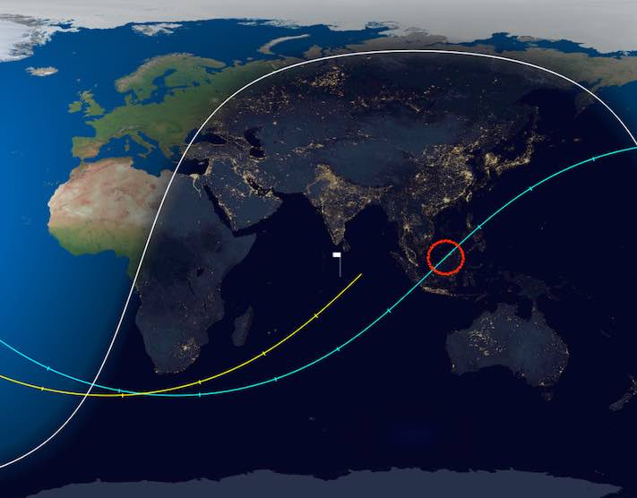
U.S. Space Command, which tracks objects in orbit, confirmed the Long March 5B rocket stage re-entered the atmosphere around 12:45 p.m. EDT (1645 GMT). The China Manned Space Agency said in a statement that any surviving debris from the rocket fell into the Sulu Sea around 9.1 degrees north latitude and 119 degrees east longitude.

Multiple posts on social media, including the one below, showed what appeared to be debris from the Long March 5B rocket burning up in the atmosphere. The tweet below shows a video captured in Kuching, Malaysia, on the island of Borneo.

There were no immediate reports of any debris landing near populated areas, but the unguided re-entry raised concerns about China’s practices for disposal of space junk.

“The People’s Republic of China (PRC) did not share specific trajectory information as their Long March 5B rocket fell back to Earth,” NASA Administrator Bill Nelson said in a statement Saturday.

“All spacefaring nations should follow established best practices, and do their part to share this type of information in advance to allow reliable predictions of potential debris impact risk, especially for heavy-lift vehicles, like the Long March 5B, which carry a significant risk of loss of life and property,” Nelson said. “Doing so is critical to the responsible use of space and to ensure the safety of people here on Earth.”

The Long March 5B rocket’s orbit took it between 41.5 degrees north and south latitude during each hour-and-a-half lap around Earth. The land between those latitudes is home to about 88% of the world’s population.

“It’s low risk on a global scale, but it’s unnecessary risk, and it can affect people, so that’s why we’re talking about it,” said Ted Muelhaupt, a consultant at Aerospace Corp. and an expert on the re-entry of space debris, in a conference call with reporters before the re-entry.

It was impossible to predict exactly when and where the rocket re-enter the atmosphere, but surviving debris was expected to fall in a long, narrow footprint hundreds miles long and up to a few dozen miles across. Statistically, the rocket wreckage was most likely to fall into the ocean or in unpopulated areas.

This was the third time China has left a Long March 5B core stage in orbit to come back to Earth in an unguided manner. The uncontrolled re-entry of the first Long March 5B core stage in 2020 spread debris over the Ivory Coast. The Long March 5B re-entry last year occurred over the Indian Ocean, and no debris was found.

The window of uncertainty around when the rocket will re-enter the atmosphere was largely due to unknowns about the rocket’s orientation and the ever-changing density of the upper atmosphere, which is driven by solar activity that causes the atmosphere to expand or contact, according Muelhaupt.

The window for a re-entry estimate shrinks as the time of the event gets closer. Five days before re-entry, experts estimated the window with an error of plus or minus one day. By Saturday morning, just a few hours before re-entry, the error reduced to plus or minus one hour.

China’s Long March 5B rocket lifts off from the Wenchang launch base on Hainan Island on July 24. Credit: CASC

Aerodynamic drag eventually slowed the rocket’s velocity enough to allow Earth’s gravity to pull back into the atmosphere, where most of the booster stage will burn up. Muelhaupt estimated about 4 to 9 metric tons, or 20% to 40% of the rocket’s dry mass, would survive the scorching heat of re-entry and reach Earth’s surface.

Abandoned rocket bodies and dead satellites regularly re-enter the atmosphere. Around 50 human-made objects weighing more than a ton re-enter the atmosphere in an uncontrolled manner each year, according to Muelhaupt.

But the Long March 5B core stage that fell to Earth Saturday was the sixth largest object to re-enter the atmosphere, not including the space shuttle, Muelhaupt said.

The Aerospace Corp. estimated the probability of a piece of the Long March 5B core stage killing or injuring a person to be between 1-in-230 and 1-in-1,000, meaning there was a 99.5% chance there would be zero casualties from the re-entry.

But U.S. government policy guidelines call for managers of space missions to ensure the risk of a death or injury from a re-entry to be no higher than 1-in-10,000. The risk of harm from the Long March 5B re-entry was estimated to be at least 10 times the standard risk threshold for U.S. space missions.

“When it comes down, it will certainly exceed the 1-in-10,000 threshold that is the generally accepted guideline,” Muelhaupt said a few days before the re-entry. “And one of the reasons we’re paying particular attention to this is that in May of 2020, the first test launch of this let debris come down in Africa.”

The risk from the re-entry for any single person was even lower — 6-in-10 trillion, according to the Aerospace Corp. assessment.

“The reality is there are a number of things that you can do about this type of thing, particularly if you’re thinking ahead with your with your mission,” said Marlon Sorge, executive director of Aerospace’s Center for Orbital and Reentry Debris Studies.

For example, designers can select materials that are more likely to burn up during re-entry, reducing the risk of any debris surviving to impact Earth’s surface.

“With the rocket bodies, they’re just so big that it doesn’t really matter what you do during during your design phase in terms of what you make it of. You’ve got huge chunks of metal where the engines are,” Sorge said.

“But there are other approaches that you can do if you think head, and one of those is controlled re-entry,” Sorge said. “Basically, once you’re done delivering your payload, you turn your rocket around, fire the engine and drive it back into the ocean somewhere, usually, someplace where there’s no population. You do that, and you have pretty much mitigated the risk right there. And that’s one of the things that is done by the U.S. government to mitigate these types of risks.”

Wang Wenbin, a spokesperson for the Chinese Foreign Ministry, said in a press conference last year that it is “common practice” for upper stages of rockets to burn up while re-entering the atmosphere. He incorrectly referred to the Long March 5B rocket body as an upper stage, and said that “most of its parts will burn up upon re-entry, making the likelihood of damage to aviation or ground facilities and activities extremely low.”

But no other launcher in the world leaves such a massive component in orbit to fall back to Earth. Dead satellites and old rocket stages regularly re-enter the atmosphere, but re-entering objects with masses of more than a few tons are rare.

“Why are we worried? Well, it did cause property damage the last time (a Long March 5B re-entered),” Muelhaupt said this week. “People are having to do preparation as a result.

“And furthermore, this is not needed,” he said. “We have the technology to not have this problem. Every time you see a Falcon 9 land, that core stage is not going to fall somewhere randomly. Bringing things down deliberately in the ocean, when they’re big enough to cause damage, that is the practice we’d like to encourage.”

China plans to launch its next space station module on another Long March 5B rocket in October. The core stage from that mission is expected to make another uncontrolled re-entry one-to-two weeks after launch.

Email the author.

Follow Stephen Clark on Twitter: @StephenClark1.

Adblock test (Why?)

728x90x4

Source link

Continue Reading

Science

Joint NASA, CNES Water-Tracking Satellite Reveals First Stunning Views – Space Ref

Published

 on


This visualization shows water features on New York’s Long Island – shown as bright pink splotches. Purple, yellow, green, and dark blue shades represent different land elevations, while the surrounding ocean is a lighter blue. The data was collected on Jan. 21, 2023, by SWOT’s KaRIn instrument. Credit: NASA/JPL-Caltech

The Surface Water and Ocean Topography mission offers the first taste of the detailed perspectives of Earth’s surface water that its cutting-edge instruments will be able to capture.

The international Surface Water and Ocean Topography (SWOT) mission – led by NASA and the French space agency Centre National d’Études Spatiales (CNES) – has sent back some of its first glimpses of water on the planet’s surface, showing ocean currents like the Gulf Stream in unprecedented detail. SWOT is also capturing views of freshwater features such as lakes, rivers, and other water bodies down to about 300 feet (100 meters) wide.

300x250x1

The satellite will measure the elevation of nearly all the water on Earth’s surface and provide one of the most comprehensive surveys yet of our planet’s surface water. SWOT’s measurements of freshwater bodies and the ocean will provide insights into how the ocean influences climate change and the water cycle; how a warming world affects water storage in lakes, rivers, and reservoirs; and how communities can better manage their water resources and prepare for floods and other disasters.

“SWOT’s advanced imagery will empower researchers and advance the way we manage fresh water and the effects of sea level rise across the globe,” said NASA Administrator Bill Nelson. “Water is one of our planet’s most important resources – and it’s proven to be vulnerable to the impacts of climate change. SWOT will provide critical information that communities can use to prepare for the impacts of a warming climate.”

A Whole New View

As seen in these early images, on Jan. 21, 2023, SWOT measured sea level in a part of the Gulf Stream off the coast of North Carolina and Virginia. The two antennas of SWOT’s Ka-band Radar Interferometer (KaRIn) instrument acquired data that was mapped as a pair of wide, colored strips spanning a total of 75 miles (120 kilometers) across. Red and orange areas in the images represent sea levels that are higher than the global average, while the shades of blue represent sea levels that are lower than average.

For comparison, the new data is shown alongside sea surface height data taken by space-based instruments called altimeters. The instruments – widely used to measure sea level – also bounce radar signals off of Earth’s surface to collect their measurements. But traditional altimeters are able to look only at a narrow beam of Earth directly beneath them, unlike KaRIn’s two wide-swath strips that observe sea level as a two-dimensional map.

The spatial resolution of SWOT ocean measurements is 10 times greater than the composite of sea surface height data gathered over the same area by seven other satellites: Sentinel-6 Michael Freilich, Jason-3, Sentinel-3A and 3B, Cryosat-2, Altika, and Hai Yang 2B. The composite image was created using information from the Copernicus Marine Service of ESA (European Space Agency) and shows the same day as the SWOT data.

KaRIn also measured the elevation of water features on Long Island – shown as bright pink splotches nestled within the landscape. (Purple, yellow, green, and blue shades represent different land elevations.)

“Our ability to measure freshwater resources on a global scale through satellite data is of prime importance as we seek to adjust to a changing climate,” said CNES Chairman and CEO Philippe Baptiste. “In this respect, the first views from SWOT give us a clearer picture than ever before. These data will prove highly valuable for the international scientific community in the fields of hydrology, oceanography, and coastal studies.”

This initial inland image is a tantalizing indication of how SWOT can measure details of smaller lakes, ponds, and rivers in ways that satellites could not before. Such data will be used to produce an extraordinary accounting of the freshwater on Earth’s surface in ways useful to researchers, policymakers, and water resource managers.

“The KaRIn instrument took years to develop and build, and it will collect information on bodies of water across the globe – data that will be freely and openly available to everybody who needs it,” said Parag Vaze, SWOT project manager at NASA’s Jet Propulsion Laboratory in Southern California.

More About the Mission

Launched on Dec. 16, 2022, from Vandenberg Space Force Base in central California, SWOT is now in a period of commissioning, calibration, and validation. Engineers are checking out the performance of the satellite’s systems and science instruments before the planned start of science operations in summer 2023.

The data for these first images was collected by SWOT’s KaRIn instrument, the scientific heart of the satellite. KaRIn has one antenna at each end of a boom that’s 33 feet (10 meters) long. This enables the instrument to look off to either side of a center line directly below the satellite as it bounces microwave signals off Earth’s surface. The returning radar signals arrive at each antenna slightly out of sync, or phase, from one another. When these signals are combined with other information about the antennas and the satellite’s altitude, scientists will be able to map the height of water on Earth’s surface with never-before-seen clarity. KaRIn encountered an issue earlier this year with one of its subsystems; engineers have now resolved the situation, and the instrument is up and running.

SWOT was jointly developed by NASA and CNES, with contributions from the Canadian Space Agency (CSA) and the UK Space Agency. JPL, which is managed for NASA by Caltech in Pasadena, California, leads the U.S. component of the project. For the flight system payload, NASA provided the KaRIn instrument, a GPS science receiver, a laser retroreflector, a two-beam microwave radiometer, and NASA instrument operations. CNES provided the Doppler Orbitography and Radioposition Integrated by Satellite (DORIS) system, the dual frequency Poseidon altimeter (developed by Thales Alenia Space), the KaRIn radio-frequency subsystem (together with Thales Alenia Space and with support from the UK Space Agency), the satellite platform, and ground operations. CSA provided the KaRIn high-power transmitter assembly. NASA provided the launch vehicle and the agency’s Launch Services Program, based at Kennedy Space Center, managed the associated launch services.

To learn more about SWOT, visit: https://swot.jpl.nasa.gov/

Adblock test (Why?)

728x90x4

Source link

Continue Reading

Science

Severe solar storm hits Earth, strongest in past 6 years – Indiatimes.com

Published

 on


The Earth witnessed a powerful solar storm in nearly six years, causing auroras all over the US, the National Oceanic and Atmospheric Administration (NOAA) said. NOAA had earlier announced moderate G2 storm and G3 conditions between March 23 and 25, but updated it to G4. A severe G4 storm can affect the power grid system with possible widespread voltage control problems; and spacecraft operations with increased possibility of surface charging, and atmospheric drag risk on Low Earth Orbiting (LEO) satellites.

Adblock test (Why?)

728x90x4

Source link

300x250x1
Continue Reading

Science

Parade of five planets on display in B.C. skies Tuesday evening

Published

 on

Five of the sun’s eight major planets will be lined up on the western horizon this Tuesday just after sunset.

The astronomical delight will comprise Mercury, Venus, Mars, Jupiter and Uranus — all in a visible line from the horizon to the crescent moon.

NASA astronomer Bill Cooke says the best way to get a glimpse is to stand somewhere with a clear view of the western horizon.

The planets will stretch from the horizon to halfway up the night sky.

300x250x1

Mercury and Jupiter (the first and fifth planets from the sun) will dip below the horizon around 30 minutes after sunset, that is 7:37 p.m. on Tuesday.

The five-planet spread can be seen anywhere on Earth.

Venus, Mars and Jupiter will be the brightest, particularly Venus, and Mars will be closest to the moon. Mercury and Uranus will be the dimmest, so a set of binoculars will be useful.

Uranus is the rarest seen of the planetary lineup.

728x90x4

Source link

Continue Reading

Trending