adplus-dvertising
Connect with us

Science

Satellites now get full-year view of Arctic sea-ice – BBC

Published

 on


AWI/S.Graupner

Satellites can now measure the thickness of sea-ice covering the Arctic Ocean all year round.

Traditionally, spacecraft have struggled to determine the full state of the floes in summer months because the presence of surface meltwater has befuddled their instruments.

But by using new “deep learning” techniques, scientists have pushed past this limitation to get reliable observations across all seasons.

300x250x1

The breakthrough has wide implications.

Apart from the obvious advantage to ships, which need to know those parts of the Arctic that will be safe to navigate, there are significant benefits to climate and weather forecasting.

At the moment, there is considerable variation in the projections for when the polar ocean might be totally free of ice in an ever warmer world.

Having an improved insight into the melting processes in those key months when floes are being reduced, in area and thickness, ought now to sharpen the output from computer models.

“Despite excellent efforts by many researchers, these climate models’ predictions of when we’ll see the first fully ice-free Arctic Ocean in summer – they vary by 30-plus years,” Dr Jack Landy, from UiT The Arctic University of Norway, told BBC News.

“We need to tighten those predictions so we’re a lot more confident about what’s going to happen and when – and how the climate feedbacks will accelerate as a consequence.”

This video can not be played

To play this video you need to enable JavaScript in your browser.

The extent of Arctic sea-ice cover has been in decline for the entire period that satellites have been monitoring it, which is more than 40 years – a reduction running at an average rate of 13% per decade.

But it’s only really since 2011 that spacecraft have been able to consistently measure its thickness – and thickness (or more properly, volume) is the true measure of the floes’ health.

That’s because the extent of sea-ice cover is heavily dependent on whether the winds have spread out the floes or pushed them together.

To measure thickness, scientists use satellite altimeters.

The European Space Agency’s (Esa) pioneering Cryosat-2 mission carries a radar to measure the difference in height between the top of the marine ice and the top of the water in the cracks, or leads, that separate the floes.

From this difference, scientists can then, with a relatively simple calculation, work out the thickness of the ice.

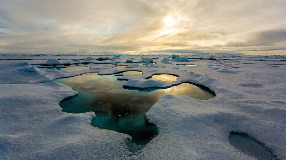
The approach works well in winter months, but in summer, when the snows on top of the ice, and the ice itself, start to melt, pooling water effectively dazzles the radar. Scientists can’t be sure if the echo signal that returns to Cryosat is coming from the open ocean or from the surface of a meltpond sitting on the ice.

May through to September – the key melt season – has been a blind period for the spacecraft.

To solve the problem, researchers used an artificial intelligence (AI) technique in which an algorithm was able to learn and identify reliable observations from a vast library of synthetic radar signals.

Ice ridge

Seymour Laxon

Prof Julienne Stroeve, from University College London (UCL), explained: “We simulated what would be the echo shapes that we would get for different ice surface types – whether they had meltponds; whether it was flooded ice; or ice of different roughnesses; or simply leads. We created this huge database of physically based estimates of what the radar return should look like, and then we matched those to the individual radar pulses from the instrument to find echoes that matched the best.”

Esa has kept in its data archives all the Cryosat May-to-September measurements, even though for the past decade they’ve been of next to no use. But now, thanks to this new approach, Dr Landy’s team has been able to go back through the records to recover full-year ice thickness measurements for the entire time the satellite has been operational.

Dr Rachel Tilling worked extensively with Cryosat data before transferring her studies to the US space agency’s recently launched Icesat-2 laser altimeter mission.

She applauded the innovation.

“Summer is when sea-ice extent in the Arctic is seeing its most rapid decline, and having this extra dimension will help us understand more about how the ice pack is changing,” the Nasa scientist told BBC News.

“Icesat-2 has its own unique difficulties in summer but we’re lucky that its photon-counting technology means we can still measure the height of sea-ice, water and melt ponds year-round.

“Having said that, Cryosat-2 will always be my first love so I’m really excited to see it being used in this novel way.”

Meltponds

AWI/S.Hendricks

A chief beneficiary of the new thickness measurements would be Inuit populations in the Arctic, said Dr Michel Tsamados, also from UCL.

“[They] have identified sea-ice roughness and slush (melted snow and ice) as a key impediment for safe travel on the ice with the changing climate already negatively affecting these characteristics and causing increased travel accidents and search-and-rescues,” he explained.

“Both are related to the thickness of the ice. Therefore, measuring throughout the full year the sea-ice thickness from space from Cryosat-2 but also Icesat-2 and other satellite sensors will eventually help provide better maps to the Inuit populations for safe travel over this rapidly changing terrain.”

Dr Landy and colleague have published their new Cryosat approach in the journal Nature.

Presentational grey line

How to measure sea-ice thickness

How Cryosat measures sea-ice volume - graphic

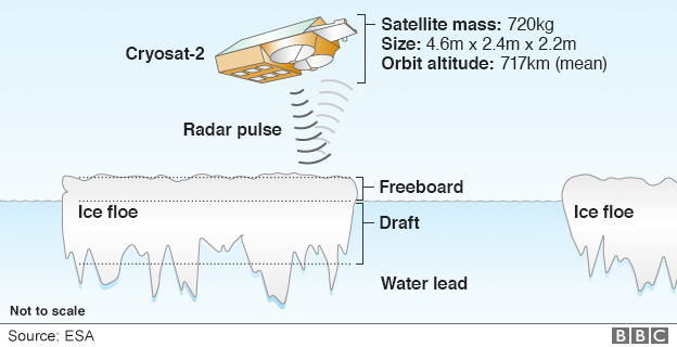
  • Cryosat’s radar has the resolution to see the Arctic’s “floes” and “leads”
  • Some 8/9ths of the ice tends to sit below the waterline – the draft
  • The radar senses the height of the freeboard – the ice above the waterline
  • Knowing this 1/9th figure allows Cryosat to work out sea-ice thickness
  • The thickness multiplied by the area of ice cover produces a volume
  • Icesat-2 does exactly the same as Cryosat but with a laser instrument
  • The biggest uncertainty for both is the covering of snow on the ice

Presentational grey line

Adblock test (Why?)

728x90x4

Source link

Continue Reading

Science

NASA hears from Voyager 1, the most distant spacecraft from Earth, after months of quiet

Published

 on


CAPE CANAVERAL, Fla. (AP) – NASA has finally heard back from Voyager 1 again in a way that makes sense.

The most distant spacecraft from Earth stopped sending back understandable data last November. Flight controllers traced the blank communication to a bad computer chip and rearranged the spacecraft’s coding to work around the trouble.

NASA’s Jet Propulsion Laboratory in Southern California declared success after receiving good engineering updates late last week. The team is still working to restore transmission of the science data.

300x250x1

It takes 22 1/2 hours to send a signal to Voyager 1, more than 15 billion miles (24 billion kilometers) away in interstellar space. The signal travel time is double that for a round trip.

Contact was never lost, rather it was like making a phone call where you can’t hear the person on the other end, a JPL spokeswoman said Tuesday.

Launched in 1977 to study Jupiter and Saturn, Voyager 1 has been exploring interstellar space – the space between star systems – since 2012. Its twin, Voyager 2, is 12.6 billion miles (20 billion kilometers) away and still working fine.


728x90x4

Source link

Continue Reading

Science

SpaceX launches 23 Starlink satellites from Florida (photos)

Published

 on

SpaceX sent yet another batch of its Starlink internet satellites skyward today (April 23).

A Falcon 9 rocket topped with 23 Starlink spacecraft lifted off from Florida’s Cape Canaveral Space Force Station today at 6:17 p.m. EDT (2217 GMT).

The Falcon 9’s first stage came back to Earth for a vertical landing about 8.5 minutes after launch as planned. It touched down on the SpaceX droneship Just Read the Instructions, which was stationed in the Atlantic Ocean.

It was the ninth launch and landing for this particular booster, according to a SpaceX mission description. Five of its previous eight liftoffs were Starlink missions.

300x250x1

The Falcon 9’s upper stage will continue carrying the 23 Starlink satellites toward low Earth orbit (LEO) today, deploying them about 65 minutes after liftoff.

This evening’s launch was the 41st of the year for SpaceX, and the 28th of 2024 dedicated to building out the huge and ever-growing Starlink megaconstellation. There are nearly 5,800 operational Starlink satellites in LEO at the moment, according to astrophysicist and satellite tracker Jonathan McDowell.

The Starlink launch ended up being the first half of a spaceflight doubleheader: A Rocket Lab Electron vehicle launched two satellites, including a NASA solar-sailing technology demonstrator, from New Zealand today at 6:33 p.m. EDT (2233 GMT).

Editor’s note: This story was updated at 6:30 p.m. ET on April 23 with news of successful launch and first-stage landing.


728x90x4

Source link

Continue Reading

Science

Exploring ecological networks in a digital world | News | Vancouver Island University | Canada – Vancouver Island University News

Published

 on


Getting to know Samantha Letourneau

By day, Samantha Letourneau is Vancouver Island University’s Canada Learning Bond project lead and Volunteer Tutor Coordinator. She’s also a musician and dancer and for the past two years, she’s been collaborating with Swedish artist Mårten Spångberg, thanks to funding obtained through Crimson Coast Dance, to create a digital art installation that goes live on Friday, April 26. A launch event takes place at Black Rabbit restaurant in the Old City Quarter that night. Samantha is also hosting a creative process workshop on April 27 and 28.

Can you share a bit about your background as an artist and how you got into it?

I have been working in art for a very long time, as a musician and dancer as well as an art administrator and program coordinator. I started music at the age of 11 and dance came later in my life in my early 20s. I always wanted to do dance, but I grew up in a small community in Yellowknife and at that time the only dance classes available were highland dancing, which I was not very interested in. 

In my early 20s while living in Vancouver, I took classes in contemporary dance and was fortunate to land a small part in the Karen Jameison Dance company for a piece called The River. The River was about rivers and connection between the reality of a real and physical outdoor river and the different reality of “the river within.” It was both a piece of art and outreach for the community. It included working with the S’pak’wus Slu’lum Dancers of the Squamish Nation. Somewhat ground-breaking for 1998.

300x250x1

From there I was hooked and wanted to do more in dance. I studied a lot and took many classes. Fast forward to now, I have been involved with productions and performances with Crimson Coast Dance for more than 15 years and greatly appreciate the talent and innovation that Artistic Director Holly Bright has brought to this community. She is amazing and very supportive of artists in Nanaimo.

How did this international exchange come about?

The Nordic/Nanaimo exchange is one of the innovative projects Holly created. At the height of the pandemic, funded by BC Arts Council and Made In BC, Crimson Coast Dance embarked on a project that explored the ways in which Nanaimo artists could participate in online exchanges. 

Two artists in Nanaimo – myself and Genevieve Johnson – were introduced to artists from Europe and supported through this international exchange. My collaborator, Mårten Spångberg, is a Swedish artist living and working in Berlin. An extension of that exchange is funded by Canada Council for the Arts – Digital Now.

What brought Mårten and myself together – and I quote Mårten here – is “questions around climate change, ecology and the influence contemporary society has on its environments. We are not interested in making art about the ecological crises or informing our audience about the urgency that climate change implies, but instead through our research develop work that in itself proposes, practices and engages in alternative ecologies.”

We share an understanding that art is a unique place, in the sense of practice, activation, performance and event, through which alternative ecologies can emerge and be probed and analyzed.

Tell us about the launch event.

We are launching the digital art installation that Mårten and I created on April 26 at The Attic at Black Rabbit Restaurant. The event is free to attend but people must sign up as seating is limited. I produced video art with soundscapes that I recorded mixing field recordings with voice and instrumentation. Marten explores text, imagery and AI.

My focus is on the evolving and ongoing process of how we communicate with each other and to nature within a digital context.

During our collaboration, Mårten and I talked about networks, though not just the expansive digital network of the internet but of nature. We shared thoughts on mycelium, a network of fungal threads or hyphae, that lately has received much attention on the importance of its function for the environment, including human beings.

Building off this concept, ideas of digital and ecological landscapes being connected emerged. From this we worked both collaboratively and individually to produce material for this digital project. Mårten will be there via Zoom as well and we will talk about this two-year process and the work we created together.

Adblock test (Why?)

728x90x4

Source link

Continue Reading

Trending