adplus-dvertising
Connect with us

Science

Space News: NASA's Curiosity Rover finds patches of rock record erased, revealing clues – Lake County News

Published

 on


A self-portrait of NASA’s Curiosity rover taken on June 15, 2018, during the 2,082nd Martian day, or sol, of Curiosity’s work on Mars. A Martian dust storm has reduced sunlight and visibility at the rover’s location in Gale Crater. Image credit: NASA/JPL-Caltech.

Today, Mars is a planet of extremes — it’s bitterly cold, has high radiation, and is bone-dry.

But billions of years ago, Mars was home to lake systems that could have sustained microbial life. As the planet’s climate changed, one such lake — in Mars’ Gale Crater — slowly dried out.

Scientists have new evidence that super salty water, or brines, seeped deep through the cracks, between grains of soil in the parched lake bottom and altered the clay mineral-rich layers beneath.

300x250x1

The findings published in the July 9 edition of the journal Science and led by the team in charge of the Chemistry and Mineralogy, or CheMin, instrument — aboard NASA’s Mars Science Laboratory Curiosity rover — help add to the understanding of where the rock record preserved or destroyed evidence of Mars’ past and possible signs of ancient life.

“We used to think that once these layers of clay minerals formed at the bottom of the lake in Gale Crater, they stayed that way, preserving the moment in time they formed for billions of years,” said Tom Bristow, CheMin principal investigator and lead author of the paper at NASA’s Ames Research Center in California’s Silicon Valley. “But later brines broke down these clay minerals in some places – essentially re-setting the rock record.”

The network of cracks in this Martian rock slab called “Old Soaker” may have formed from the drying of a mud layer more than three billion years ago. The view spans about three feet (90 centimeters) left-to-right and combines three images taken by the Mars Hand Lens Imager, or MAHLI, camera on the arm of NASA’s Curiosity Mars rover. Credits: NASA/JPL-Caltech/MSSS.

Mars: It goes on your permanent record

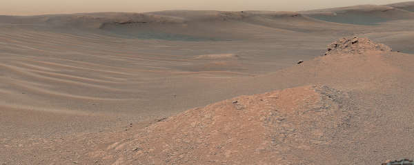
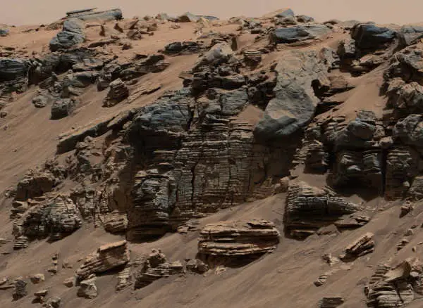
Mars has a treasure trove of incredibly ancient rocks and minerals compared with Earth. And with Gale Crater’s undisturbed layers of rocks, scientists knew it would be an excellent site to search for evidence of the planet’s history, and possibly life.

Using CheMin, scientists compared samples taken from two areas about a quarter-mile apart from a layer of mudstone deposited billions of years ago at the bottom of the lake at Gale Crater.

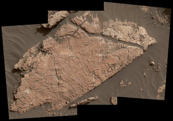
Surprisingly, in one area, about half the clay minerals they expected to find were missing. Instead, they found mudstones rich with iron oxides — minerals that give Mars its characteristic rusty red color.

Scientists knew the mudstones sampled were about the same age and started out the same – loaded with clays — in both areas studied.

So why then, as Curiosity explored the sedimentary clay deposits along Gale Crater did patches of clay minerals — and the evidence they preserve — “disappear”?

This evenly layered rock imaged in 2014 by the Mastcam on NASA’s Curiosity Mars rover shows a pattern typical of a lake-floor sedimentary deposit near where flowing water entered a lake. Shallow and deep parts of an ancient Martian lake left different clues in mudstone formed from lakebed deposits. Credits: NASA/JPL-Caltech/MSSS.

Clays hold clues

Minerals are like a time capsule; they provide a record of what the environment was like at the time they formed. Clay minerals have water in their structure and are evidence that the soils and rocks that contain them came into contact with water at some point.

“Since the minerals we find on Mars also form in some locations on Earth, we can use what we know about how they form on Earth to tell us about how salty or acidic the waters on ancient Mars were,” said Liz Rampe, CheMin deputy principal investigator and co-author at NASA’s Johnson Space Center in Houston.

Previous work revealed that, while Gale Crater’s lakes were present and even after they dried out, groundwater moved below the surface, dissolving and transporting chemicals.

After they were deposited and buried, some mudstone pockets experienced different conditions and processes due to interactions with these waters that changed the mineralogy.

This process, known as “diagenesis,” often complicates or erases the soil’s previous history and writes a new one.

Diagenesis creates an underground environment that can support microbial life. In fact, some very unique habitats on Earth — in which microbes thrive — are known as “deep biospheres.”

“These are excellent places to look for evidence of ancient life and gauge habitability,” said John Grotzinger, CheMin co-investigator and co-author at Caltech in Pasadena, California. “Even though diagenesis may erase the signs of life in the original lake, it creates the chemical gradients necessary to support subsurface life, so we are really excited to have discovered this.”

By comparing the details of minerals from both samples, the team concluded that briny water filtering down through overlying sediment layers was responsible for the changes. Unlike the relatively freshwater lake present when the mudstones formed, the salty water is suspected to have come from later lakes that existed within an overall drier environment.

Scientists believe these results offer further evidence of the impacts of Mars’s climate change billions of years ago. They also provide more detailed information that is then used to guide the Curiosity rover’s investigations into the history of the Red Planet.

This information also will be utilized by NASA’s Mars 2020 Perseverance rover team as they evaluate and select rock samples for eventual return to Earth.

“We’ve learned something very important: there are some parts of the Martian rock record that aren’t so good at preserving evidence of the planet’s past and possible life,” said Ashwin Vasavada, Curiosity project scientist and co-author at NASA’s Jet Propulsion Laboratory in Southern California. “The fortunate thing is we find both close together in Gale Crater, and can use mineralogy to tell which is which.”

Curiosity is in the initial phase of investigating the transition to a “sulfate-bearing unit,” or rocks thought to have formed while Mars’s climate dried out.

The mission is managed by JPL, a division of Caltech, for NASA’s Science Mission Directorate, Washington. Colleagues in NASA’s Astromaterials Research and Exploration Science Division at Johnson and NASA’s Goddard Space Flight Center in Greenbelt, Maryland also are authors on the paper, as well as other institutions working on Curiosity.

This Martian landscape includes the rocky landmark nicknamed “Knockfarril Hill” at center right and the edge of Vera Rubin Ridge, which runs along the top of the scene. The image was made from a mosaic captured by the Mast Camera aboard NASA’s Curiosity Mars rover as it explored the “clay-bearing unit” on Feb. 3, 2019, during the 2,309th Martian day, or sol, of Curiosity’s work on Mars. Credits: NASA/JPL-Caltech/MSSS.

Adblock test (Why?)

728x90x4

Source link

Continue Reading

Science

SpaceX sends 23 Starlink satellites into low-Earth orbit – UPI News

Published

 on


April 23 (UPI) — SpaceX launched 23 Starlink satellites into low-Earth orbit Tuesday evening from Space Launch Complex 40 at Cape Canaveral Space Force Station in Florida.

Liftoff occurred at 6:17 EDT with a SpaceX Falcon 9 rocket sending the payload of 23 Starlink satellites into orbit.

The Falcon 9 rocket’s first-stage booster landed on an autonomous drone ship in the Atlantic Ocean after separating from the rocket’s second stage and its payload.

300x250x1

The entire mission was scheduled to take about an hour and 5 minutes to complete from launch to satellite deployment.

The mission was the ninth flight for the first-stage booster that previously completed five Starlink satellite-deployment missions and three other missions.

Adblock test (Why?)

728x90x4

Source link

Continue Reading

Science

NASA Celebrates As 1977’s Voyager 1 Phones Home At Last

Published

 on

Voyager 1 has finally returned usable data to NASA from outside the solar system after five months offline.

Launched in 1977 and now in its 46th year, the probe has been suffering from communication issues since November 14. The same thing also happened in 2022. However, this week, NASA said that engineers were finally able to get usable data about the health and status of its onboard engineering systems.

Slow Work

Fixing Voyager 1 has been slow work. It’s currently over 15 billion miles (24 billion kilometers) from Earth, which means a radio message takes about 22.5 hours to reach it—and the same again to receive an answer.

The problem appears to have been its flight data subsystem, one of one of the spacecraft’s three onboard computers. Its job is to package the science and engineering data before it’s sent to Earth. Since the computer chip that stores its memory and some of its code is broken, engineers had to re-insert that code into a new location.

300x250x1

Next up for engineers at NASA’s Jet Propulsion Laboratory in California is to adjust other parts of the FDS software so Voyager 1 can return to sending science data.

Beyond The ‘Heliopause’

The longest-running and most distant spacecraft in history, Voyager 1, was launched on September 5, 1977, while its twin spacecraft, Voyager 2, was launched a little earlier on August 20, 1977. Voyager 2—now 12 billion miles away and traveling more slowly—continues to operate normally.

Both are now beyond what astronomers call the heliopause—a protective bubble of particles and magnetic fields created by the sun, which is thought to represent the sun’s farthest influence. Voyager 1 got to the heliopause in 2012 and Voyager 2 in 2018.

Pale Blue Dot

Since their launch from Cape Canaveral, Florida, aboard Titan-Centaur rockets, Voyager 1 and Voyager 2 have had glittering careers. Both photographed Jupiter and Saturn in 1979 and 1980 before going their separate ways. Voyager 1 could have visited Pluto, but that was sacrificed so scientists could get images of Saturn’s moon, Titan, a maneuver that made it impossible for it to reach any other body in the solar system. Meanwhile, Voyager 2 took slingshots around the planets to also image Uranus in 1986 and Neptune in 1989—the only spacecraft ever to image the two outer planets.

On February 14, 1990, when 3.7 billion miles from Earth, Voyager 1 turned its cameras back towards the sun and took an image that included our planet as “a mote of dust suspended in a sunbeam.” Known as the “Pale Blue Dot,” it’s one of the most famous photos ever taken. It was remastered in 2019.

Adblock test (Why?)

728x90x4

Source link

Continue Reading

Science

NASA hears from Voyager 1, the most distant spacecraft from Earth, after months of quiet

Published

 on


CAPE CANAVERAL, Fla. (AP) – NASA has finally heard back from Voyager 1 again in a way that makes sense.

The most distant spacecraft from Earth stopped sending back understandable data last November. Flight controllers traced the blank communication to a bad computer chip and rearranged the spacecraft’s coding to work around the trouble.

NASA’s Jet Propulsion Laboratory in Southern California declared success after receiving good engineering updates late last week. The team is still working to restore transmission of the science data.

300x250x1

It takes 22 1/2 hours to send a signal to Voyager 1, more than 15 billion miles (24 billion kilometers) away in interstellar space. The signal travel time is double that for a round trip.

Contact was never lost, rather it was like making a phone call where you can’t hear the person on the other end, a JPL spokeswoman said Tuesday.

Launched in 1977 to study Jupiter and Saturn, Voyager 1 has been exploring interstellar space – the space between star systems – since 2012. Its twin, Voyager 2, is 12.6 billion miles (20 billion kilometers) away and still working fine.


728x90x4

Source link

Continue Reading

Trending