


After parts of Atlantic Canada saw a modest amount of snowfall on the weekend, the next shot of it is already en route courtesy of an intensifying low-pressure system. Most of Monday will have fair conditions across the region, with the low’s impacts to push in through the overnight hours to parts of the Maritimes. Tuesday will be a messy day, particularly for southern Nova Scotia, where snow will change to rain, which will be heavy at times. Accumulations won’t be too heavy, but up to 15 cm could fall in Cape Breton and portions of Newfoundland, accompanied by some blustery winds. For a closer look, see below.
WEATHER HIGHLIGHTS
- Snow to arrive in the Maritimes Monday night, changes to rain in southern Nova Scotia Tuesday morning
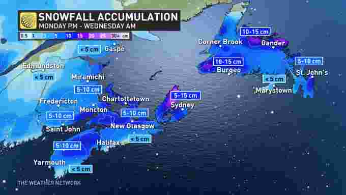
- 5-15 cm of snow expected, depending on location
- Forecasters monitoring another potential system late week
MONDAY NIGHT/TUESDAY: MESSY SYSTEM TO BRING RAIN, ANOTHER SHOT OF SNOW
While parts of Atlantic Canada recovers from the weekend dumping of snow, the next storm is already taking aim at the region. The same low impacting Ontario will intensify off the northeastern U.S. coast and track into the Maritime provinces Monday overnight.
Snow will push into parts of New Brunswick and southwestern Nova Scotia in the overnight hours Monday, spreading east early Tuesday morning into the rest of the Maritimes.
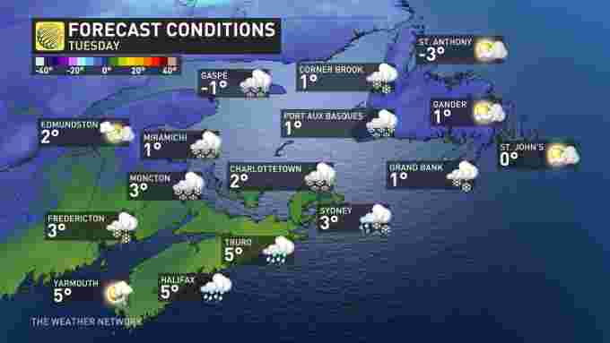
Due to the more northerly track of the system, it will pull in milder air into the southern Nova Scotia. Because of this, snow will change to rain in southwestern Nova Scotia in the morning hours Tuesday as temperatures begin to rise. This will move east as the day progresses.
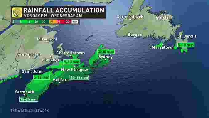
Rainfall will be heavy at times for Halifax into Tuesday afternoon. Precipitation will diminish in the Maritimes through the overnight hours. Totals will be greatest along southern shores of Nova Scotia, where 15-25 mm is anticipated.
Snowfall amounts won’t be copious with this system, with 5-10 cm expected for parts of New Brunswick, P.E.I. and northern Nova Scotia. Less than 5 cm is forecast along coastal areas of the latter because of the changeover to rain. Meanwhile, Cape Breton and portions of southwestern and eastern Newfoundland could see up to 15 cm.
Snow reaches western Newfoundland Tuesday afternoon, with a brief rain-snow mix possible for southern areas including the Avalon in the evening before changing to rain. This will continue into early Wednesday morning before it tapering off.
Along with the rain and snow, winds will ramp up Tuesday afternoon for coastal Nova Scotia and southwestern Newfoundland. Southwesterly gusts of 40-60 km/h are expected for the former, while they may exceed 70 km/h for the latter. Winds will remain blustery in Newfoundland into Wednesday morning.
Beyond the incoming system, there is also the potential for another significant system to impact the region late-week.
Check back for updates as this next storm approaches Atlantic Canada.


