WILLIAMS LAKE, B.C. – The uncertainty of how a landslide blocking British Columbia’s Chilcotin River will give way is a key concern for Chief Willie Sellars of the Williams Lake Indian Band.
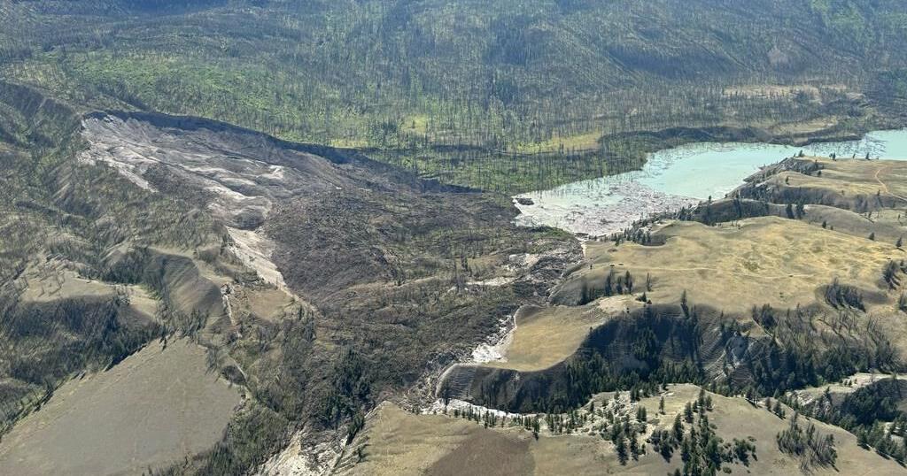
Sellars has been over the slide in a helicopter for two days in a row and said the lake behind the dam doubled in size from Wednesday to Thursday and the water continues to build.
“And it’s eventually going to get to this place where it starts overtopping the slide. And, you know, all the experts in all the calls and the feedback that we continue to hear is, is nobody really knows what is going to happen.”
Scenarios include the dam releasing all at once, or the water could trickle through, or the lake behind the dam will top the slide and allow the river flow to resume, he said.
“But there is this massive body of water that is building on the one side of that slide. And it’s scary,” he said.
“It’s hard to describe in words how massive this slide is, and how devastating it is.”
The B.C. government issued a statement late Thursday saying the water has backed up for about eight kilometres up the river, in B.C.’s Cariboo region.
The landslide material is composed of sands, silts and clays, which are “susceptible to rapid erosion,” the province said.
It said provincial personnel are monitoring the site south of Williams Lake around the clock, with help from drones and helicopters. They’re also using Light Detection And Ranging Data or LIDAR technology.
“The focus is on learning as much as possible about when and how the water is most likely to be dispersed to the Chilcotin River,” it said.
The government statement said there is “no anticipated timeline” for when the water may overtop or burst through the landslide material, though regional officials have said a release could be imminent.
Margo Wagner, chair of the Cariboo Regional District, told a news briefing on Thursday that a release could be expected within one to two days.
She said the water could reach a level where it will start flowing over the debris, or it will erode the material, setting off a release and potentially triggering dozens of evacuation orders and alerts downstream.
Evacuation orders span 107 square kilometres along the Chilcotin River, and officials say the slide poses an “immediate danger to life and safety.”
Sellars said the river has “massive cultural significance” for all the First Nations in the area, and he also has concerns for the impacts downstream if the dam bursts.
“And really, it’s hundreds of communities that are impacted and located along the Fraser (River),” he said.
B.C. Minister of Emergency Management Bowinn Ma said on Thursday that if the dam breaks it’s possible that dozens of evacuation orders and alerts would be issued as a surge of water moves down the Chilcotin River and into the Fraser River, which empties into the Strait of Georgia in Metro Vancouver.
The nearby Tsilhqot’in National Government has declared a state of local emergency and warned people to stay away from the river.
The state of the river has also prompted Interior Health to relocate 21 patients out of a hospital and long-term care home in Lillooet to alternative areas.
It said in a statement it was taking a proactive approach to plan an orderly relocation of its most vulnerable clients.
Sellars said his community is about 45 minutes away from the slide, so an evacuation of the community likely won’t be necessary.
“(There’s) a lot of history, former village sites, burial grounds, and we need to make sure that we’re doing everything we can to document and protect those,” he said.
This report by The Canadian Press was first published Aug. 2, 2024.


