adplus-dvertising
Connect with us

Science

Canada's peatlands are tinderboxes that are more likely to ignite in a warming world – The Globe and Mail

Published

 on


Scorched trees stand near Britt, Ont., in the summer of 2018 after the Parry Sound 33 forest fire swept through the area. The fire spread in a part of the country where peat is abundant.

Nathan Denette/The Canadian Press

When a devastating forest fire raged near Parry Sound, Ont., in 2018, Sophie Wilkinson, a postdoctoral researcher at McMaster University, was busy gathering data at a study site in northern Alberta. But once she knew her colleagues working near the fire were safe, all she wanted to do was get back there to see the result.

Nestled in a rocky inlet of Georgian Bay, Parry Sound is far from Canada’s Arctic and Subarctic wilderness. But the area has something in common with those more northerly reaches: an abundance of peat – dense layers of partly decayed vegetation that accumulate in moist places, generally over centuries. Long a neglected component of the landscape, peat is now in the scientific spotlight because of all the carbon that’s locked up in its pungent bulk. In a world increasingly ablaze with wildfires, the fate of that carbon is a matter of serious concern.

When peat burns, its carbon is released, and the peat switches from being a storehouse to a source of greenhouse gas emissions. This summer’s extensive fires in peat-rich Siberia loosed about as much carbon dioxide into the atmosphere as the Greater Toronto Area has generated over the past five years.

Story continues below advertisement

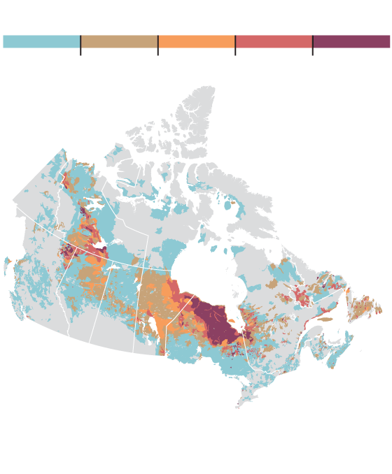
Total peatland (%)

MURAT YÜKSELIR / THE GLOBE AND MAIL, SOURCE:

GEOLOGICAL SURVEY OF CANADA

Total peatland (%)

MURAT YÜKSELIR / THE GLOBE AND MAIL, SOURCE:

GEOLOGICAL SURVEY OF CANADA

Total peatland (%)

MURAT YÜKSELIR / THE GLOBE AND MAIL, SOURCE: GEOLOGICAL SURVEY OF CANADA

Globally, peatlands are estimated to store about 550 gigatonnes of carbon, more than all of the forests in the world combined. About one-quarter of that peat is found in Canada, with particularly dense concentrations in the Hudson Bay Lowlands and the Mackenzie River basin. Studies suggest this asset in Canada’s carbon accounting is at risk due to changing patterns of wildfire.

By chance, the Parry Sound fire, which ultimately consumed 11,362 hectares of woodland, burned across an area of peat deposits that McMaster scientists, led by ecohydrologist Mike Waddington, have been studying for seven years. Dr. Wilkinson is a member of the team, and with so much information at hand about what was there before, she was able to go in after the conflagration to measure precisely what impact the fire had.

“It was utterly desolate,” she said. “There was so little soil left that most of the trees had fallen over after they had burned, as well.”

Though fire is a natural process, what was striking about the Parry Sound event was its intensity and the way it penetrated into areas that would typically be considered too wet to burn easily. Dr. Wilkinson and her colleagues found that peat deposits that were less than 70 centimetres thick were completely incinerated. Areas like this may not return as peatlands, but instead be taken over by deep-rooted deciduous trees that drink up moisture. Trees store carbon too, but peat stores more, so a net loss of peatland after a fire is bad news for the climate.

The study, published Tuesday in the journal Environmental Research Letters, comes with a silver lining. Areas of deeper peat were shown to survive the fire and stay wet enough to rebound. But the work sheds new light on how vulnerable peatlands have become in places that are burning differently than they did in the past as the climate warms.

That trend is now indisputable, said Matthew Jones, an Earth systems scientist at the University of East Anglia in the U.K. In a brief released this week, Dr. Jones and four co-authors examined 116 separate studies and found that all of them either directly strengthen or are consistent with evidence that climate change is increasing the frequency and severity of wildfires in multiple regions of the globe. Not surprisingly, among the areas most affected by the trend are those that have been prominent in the news due to record-setting fires in the past year, including California and eastern Australia.

“By and large, the picture is that of a warming, drying world – which is not helpful when it comes to fires,” Dr Jones said. He added that forward-looking studies using climate models “are all pointing to this situation getting worse the more the temperature rises.”

Story continues below advertisement

Local and Greenpeace activists extinguish a peat fire near the Siberian village of Shipunovo on Sept. 11 this year.

ALEXANDER NEMENOV/AFP via Getty Images

Haze blankets the Rockies on Sept. 21 in wetern Montana as the smoke from wildfires in the western United States moves into other regions.

Samuel Corum/Getty Images

For now, the change in Canada is less extreme than in the western U.S., but it’s heading in the same direction. While the area burned has doubled in Canada since the 1970s, in California it has increased by about a factor of five, said Mike Flannigan, a professor at the University of Alberta who studies the link between climate change and fire.

Yet, the Arctic is also warming faster than the rest of the world, and this is where peatland is likely to play a bigger role in releasing carbon, creating a positive feedback cycle that spurs warming even further.

“That can really tip the effect of the wildfire season, even if the amount of area burned doesn’t change,” Dr. Wilkinson said.

Daniel Thompson, a fire scientist with Natural Resources Canada, said that fire in Canada’s northwest is clearly on the rise and is affecting peatlands in a way that’s different from the past.

The numbers bear this out. Of the 10 most severe wildfires in Canadian history, six have occurred within the past decade, all in the northwest. These include the Fort McMurray fire of 2016, which stands as Canada’s costliest natural disaster, and the massive fires near Yellowknife in 2014, which collectively burned an area larger than all of Vancouver Island.

While the numbers are startling, “this is not a new disturbance to the system,” Dr. Thompson said. “It’s more a question of frequency and intensity.”

Many of these Canadian wildfires have been raging in areas that are covered in peat. Sometimes referred to as “zombie fires,” there’s evidence that peat fires in the North can smoulder on through the winter and resurface anew in spring. And unlike the dramatic and very visible damage that fire has wrought further south, the most profound effects may be out of sight and underground. This is because peat often overlaps with another key feature of the Northern landscape: permafrost.

Permafrost is the permanently frozen ground that persists year-round below surface soil. When the Northern landscape burns, the permafrost below loses a measure of insulation that protects it during the summer months. Instead, the blackened, sooty surface left behind in a fire’s wake is ideal for absorbing sunlight and warming up the ground.

The loss of permafrost due to climate change is already a problem for Northern communities because it destabilizes the ground and threatens infrastructure. More broadly, scientists fear that melting permafrost is releasing methane, a potent greenhouse gas, creating another feedback loop that can further accelerate climate change. In this scenario, fire adds another boost.

David Olefeldt, a wetland scientist at the University of Alberta, has been examining the interaction of peat, permafrost and fire. He said the effects are likely not all in one direction, in part because melting permafrost may also act to suppress fire. “More fire and more thaw changes the landscape to become wetter and less treed, and therefore it burns less,” he said. He’s currently studying the question, an example of how little scientists can say for certain about the fate of Northern ecosystems and their ultimate impact on the globe even as unprecedented change is under way. A shift in vegetation due to warming is yet another factor that has been difficult for researchers to take into account when modelling future change.

For Merritt Turetsky, director of the Institute of Arctic and Alpine Research at the University of Colorado, Boulder, the field is in urgent need of a co-ordinated and multidisciplinary effort to track the new reality in the North, and how changing fire conditions are playing into the story.

“We used to think of the Arctic as the last [ecosystem] unshaped by fire,” she said. “That’s not true any more.”

Story continues below advertisement

An activist works to extinguish one of Siberia’s peat fires this September.

ALEXANDER NEMENOV/AFP via Getty Images

Our Morning Update and Evening Update newsletters are written by Globe editors, giving you a concise summary of the day’s most important headlines. Sign up today.

Let’s block ads! (Why?)

728x90x4

Source link

Continue Reading

News

Here’s how Helene and other storms dumped a whopping 40 trillion gallons of rain on the South

Published

 on


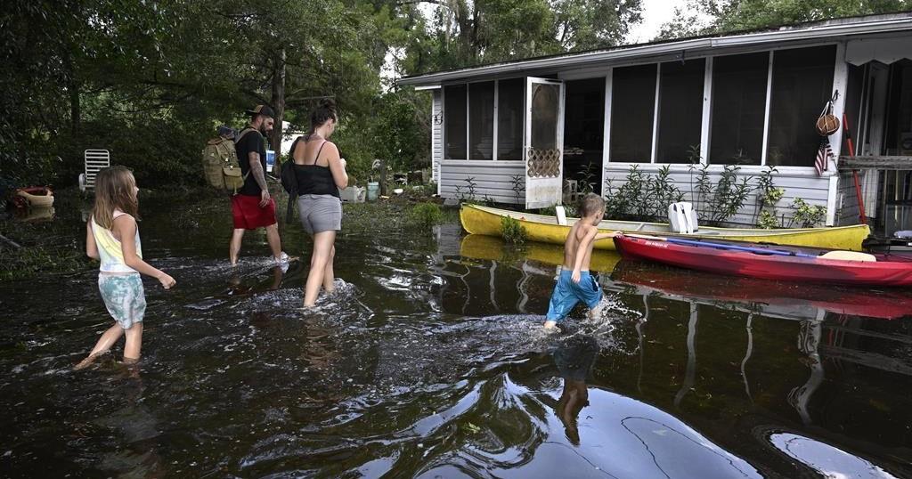
More than 40 trillion gallons of rain drenched the Southeast United States in the last week from Hurricane Helene and a run-of-the-mill rainstorm that sloshed in ahead of it — an unheard of amount of water that has stunned experts.

That’s enough to fill the Dallas Cowboys’ stadium 51,000 times, or Lake Tahoe just once. If it was concentrated just on the state of North Carolina that much water would be 3.5 feet deep (more than 1 meter). It’s enough to fill more than 60 million Olympic-size swimming pools.

“That’s an astronomical amount of precipitation,” said Ed Clark, head of the National Oceanic and Atmospheric Administration’s National Water Center in Tuscaloosa, Alabama. “I have not seen something in my 25 years of working at the weather service that is this geographically large of an extent and the sheer volume of water that fell from the sky.”

The flood damage from the rain is apocalyptic, meteorologists said. More than 100 people are dead, according to officials.

Private meteorologist Ryan Maue, a former NOAA chief scientist, calculated the amount of rain, using precipitation measurements made in 2.5-mile-by-2.5 mile grids as measured by satellites and ground observations. He came up with 40 trillion gallons through Sunday for the eastern United States, with 20 trillion gallons of that hitting just Georgia, Tennessee, the Carolinas and Florida from Hurricane Helene.

Clark did the calculations independently and said the 40 trillion gallon figure (151 trillion liters) is about right and, if anything, conservative. Maue said maybe 1 to 2 trillion more gallons of rain had fallen, much if it in Virginia, since his calculations.

Clark, who spends much of his work on issues of shrinking western water supplies, said to put the amount of rain in perspective, it’s more than twice the combined amount of water stored by two key Colorado River basin reservoirs: Lake Powell and Lake Mead.

Several meteorologists said this was a combination of two, maybe three storm systems. Before Helene struck, rain had fallen heavily for days because a low pressure system had “cut off” from the jet stream — which moves weather systems along west to east — and stalled over the Southeast. That funneled plenty of warm water from the Gulf of Mexico. And a storm that fell just short of named status parked along North Carolina’s Atlantic coast, dumping as much as 20 inches of rain, said North Carolina state climatologist Kathie Dello.

Then add Helene, one of the largest storms in the last couple decades and one that held plenty of rain because it was young and moved fast before it hit the Appalachians, said University of Albany hurricane expert Kristen Corbosiero.

“It was not just a perfect storm, but it was a combination of multiple storms that that led to the enormous amount of rain,” Maue said. “That collected at high elevation, we’re talking 3,000 to 6000 feet. And when you drop trillions of gallons on a mountain, that has to go down.”

The fact that these storms hit the mountains made everything worse, and not just because of runoff. The interaction between the mountains and the storm systems wrings more moisture out of the air, Clark, Maue and Corbosiero said.

North Carolina weather officials said their top measurement total was 31.33 inches in the tiny town of Busick. Mount Mitchell also got more than 2 feet of rainfall.

Before 2017’s Hurricane Harvey, “I said to our colleagues, you know, I never thought in my career that we would measure rainfall in feet,” Clark said. “And after Harvey, Florence, the more isolated events in eastern Kentucky, portions of South Dakota. We’re seeing events year in and year out where we are measuring rainfall in feet.”

Storms are getting wetter as the climate change s, said Corbosiero and Dello. A basic law of physics says the air holds nearly 4% more moisture for every degree Fahrenheit warmer (7% for every degree Celsius) and the world has warmed more than 2 degrees (1.2 degrees Celsius) since pre-industrial times.

Corbosiero said meteorologists are vigorously debating how much of Helene is due to worsening climate change and how much is random.

For Dello, the “fingerprints of climate change” were clear.

“We’ve seen tropical storm impacts in western North Carolina. But these storms are wetter and these storms are warmer. And there would have been a time when a tropical storm would have been heading toward North Carolina and would have caused some rain and some damage, but not apocalyptic destruction. ”

___

Follow AP’s climate coverage at https://apnews.com/hub/climate

___

Follow Seth Borenstein on Twitter at @borenbears

___

Associated Press climate and environmental coverage receives support from several private foundations. See more about AP’s climate initiative here. The AP is solely responsible for all content.

Source link

Continue Reading

Science

‘Big Sam’: Paleontologists unearth giant skull of Pachyrhinosaurus in Alberta

Published

 on


It’s a dinosaur that roamed Alberta’s badlands more than 70 million years ago, sporting a big, bumpy, bony head the size of a baby elephant.

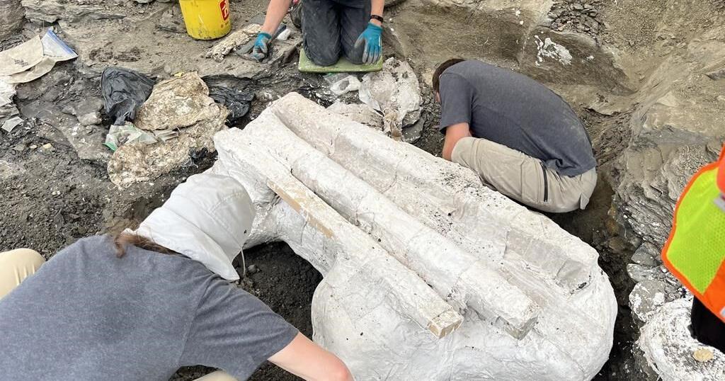
On Wednesday, paleontologists near Grande Prairie pulled its 272-kilogram skull from the ground.

They call it “Big Sam.”

The adult Pachyrhinosaurus is the second plant-eating dinosaur to be unearthed from a dense bonebed belonging to a herd that died together on the edge of a valley that now sits 450 kilometres northwest of Edmonton.

It didn’t die alone.

“We have hundreds of juvenile bones in the bonebed, so we know that there are many babies and some adults among all of the big adults,” Emily Bamforth, a paleontologist with the nearby Philip J. Currie Dinosaur Museum, said in an interview on the way to the dig site.

She described the horned Pachyrhinosaurus as “the smaller, older cousin of the triceratops.”

“This species of dinosaur is endemic to the Grand Prairie area, so it’s found here and nowhere else in the world. They are … kind of about the size of an Indian elephant and a rhino,” she added.

The head alone, she said, is about the size of a baby elephant.

The discovery was a long time coming.

The bonebed was first discovered by a high school teacher out for a walk about 50 years ago. It took the teacher a decade to get anyone from southern Alberta to come to take a look.

“At the time, sort of in the ’70s and ’80s, paleontology in northern Alberta was virtually unknown,” said Bamforth.

When paleontogists eventually got to the site, Bamforth said, they learned “it’s actually one of the densest dinosaur bonebeds in North America.”

“It contains about 100 to 300 bones per square metre,” she said.

Paleontologists have been at the site sporadically ever since, combing through bones belonging to turtles, dinosaurs and lizards. Sixteen years ago, they discovered a large skull of an approximately 30-year-old Pachyrhinosaurus, which is now at the museum.

About a year ago, they found the second adult: Big Sam.

Bamforth said both dinosaurs are believed to have been the elders in the herd.

“Their distinguishing feature is that, instead of having a horn on their nose like a triceratops, they had this big, bony bump called a boss. And they have big, bony bumps over their eyes as well,” she said.

“It makes them look a little strange. It’s the one dinosaur that if you find it, it’s the only possible thing it can be.”

The genders of the two adults are unknown.

Bamforth said the extraction was difficult because Big Sam was intertwined in a cluster of about 300 other bones.

The skull was found upside down, “as if the animal was lying on its back,” but was well preserved, she said.

She said the excavation process involved putting plaster on the skull and wooden planks around if for stability. From there, it was lifted out — very carefully — with a crane, and was to be shipped on a trolley to the museum for study.

“I have extracted skulls in the past. This is probably the biggest one I’ve ever done though,” said Bamforth.

“It’s pretty exciting.”

This report by The Canadian Press was first published Sept. 25, 2024.

The Canadian Press. All rights reserved.

Source link

Continue Reading

News

The ancient jar smashed by a 4-year-old is back on display at an Israeli museum after repair

Published

 on


TEL AVIV, Israel (AP) — A rare Bronze-Era jar accidentally smashed by a 4-year-old visiting a museum was back on display Wednesday after restoration experts were able to carefully piece the artifact back together.

Last month, a family from northern Israel was visiting the museum when their youngest son tipped over the jar, which smashed into pieces.

Alex Geller, the boy’s father, said his son — the youngest of three — is exceptionally curious, and that the moment he heard the crash, “please let that not be my child” was the first thought that raced through his head.

The jar has been on display at the Hecht Museum in Haifa for 35 years. It was one of the only containers of its size and from that period still complete when it was discovered.

The Bronze Age jar is one of many artifacts exhibited out in the open, part of the Hecht Museum’s vision of letting visitors explore history without glass barriers, said Inbal Rivlin, the director of the museum, which is associated with Haifa University in northern Israel.

It was likely used to hold wine or oil, and dates back to between 2200 and 1500 B.C.

Rivlin and the museum decided to turn the moment, which captured international attention, into a teaching moment, inviting the Geller family back for a special visit and hands-on activity to illustrate the restoration process.

Rivlin added that the incident provided a welcome distraction from the ongoing war in Gaza. “Well, he’s just a kid. So I think that somehow it touches the heart of the people in Israel and around the world,“ said Rivlin.

Roee Shafir, a restoration expert at the museum, said the repairs would be fairly simple, as the pieces were from a single, complete jar. Archaeologists often face the more daunting task of sifting through piles of shards from multiple objects and trying to piece them together.

Experts used 3D technology, hi-resolution videos, and special glue to painstakingly reconstruct the large jar.

Less than two weeks after it broke, the jar went back on display at the museum. The gluing process left small hairline cracks, and a few pieces are missing, but the jar’s impressive size remains.

The only noticeable difference in the exhibit was a new sign reading “please don’t touch.”

The Canadian Press. All rights reserved.

Source link

Continue Reading

Trending