adplus-dvertising
Connect with us

Science

Deep Impact: Heat Waves Happen at the Bottom of the Ocean Too

Published

 on

This visualization depicts bathymetric features of the western Atlantic Ocean Basin, including the continental shelf, captured by satellite. Credit: NOAA’s National Environmental Satellite and Information Service


First assessment of bottom marine heat waves opens a window on the deep.

The 2013-2016 marine heat wave known as “The Blob” warmed a vast expanse of surface waters across the northeastern Pacific, disrupting West Coast marine ecosystems, depressing salmon returns, and damaging commercial fisheries. It also prompted a wave of research on extreme warming of ocean surface waters.

But, as new research from the National Oceanic and Atmospheric Administration (<span class=”glossaryLink” aria-describedby=”tt” data-cmtooltip=”

NOAA
The National Oceanic and Atmospheric Administration (NOAA) is a scientific agency of the United States government that is focused on understanding and predicting changes in Earth’s oceans, atmosphere, and climate. It is headquartered in Silver Spring, Maryland and is a part of the Department of Commerce. NOAA conducts research and provides information, products, and services that are used to protect life and property, and to support economic growth and development. It also works to conserve and manage natural resources, including fisheries, wildlife, and habitats. Some of the specific activities that NOAA is involved in include weather forecasting, climate monitoring, marine biology and fisheries research, and satellite and remote sensing.


In a paper published in the journal <span class=”glossaryLink” aria-describedby=”tt” data-cmtooltip=”

Nature Communications
&lt;em&gt;Nature Communications&lt;/em&gt; is a peer-reviewed, open-access, multidisciplinary, scientific journal published by Nature Portfolio. It covers the natural sciences, including physics, biology, chemistry, medicine, and earth sciences. It began publishing in 2010 and has editorial offices in London, Berlin, New York City, and Shanghai.&nbsp;

” data-gt-translate-attributes=”[“attribute”:”data-cmtooltip”, “format”:”html”]”>Nature Communications on March 13, a team led by NOAA researchers used a combination of observations and computer models to generate the first broad assessment of bottom marine heat waves in the productive continental shelf waters surrounding North America.

Endangered Fish Marine Heat Waves

Marine heat waves have a significant impact on ocean ecosystems globally, disrupting the productivity and distribution of organisms, from plankton to whales. There is a significant effort to study, track, and predict the timing, intensity, duration, and physical drivers of these events. Credit: NOAA Fisheries


“Researchers have been investigating marine heat waves at the sea surface for over a decade now,” said lead author Dillon Amaya, a research scientist with NOAA’s Physical Science Laboratory. “This is the first time we’ve been able to really dive deeper and assess how these extreme events unfold along shallow seafloors.”


Marine heat waves dramatically impact the health of ocean ecosystems around the globe, disrupting the productivity and distribution of organisms as small as plankton and as large as whales. As a result, there has been a considerable effort to study, track and predict the timing, intensity, duration, and physical drivers of these events.

Most of that research has focused on temperature extremes at the ocean’s surface, for which there are many more high-quality observations taken by satellites, ships, and buoys. Sea surface temperatures can also be indicators for many physical and biochemical ocean characteristics of sensitive marine ecosystems, making analyses more straightforward.

About 90% of the excess heat from global warming has been absorbed by the ocean, which has warmed by about 1.5C over the past century. Marine heatwaves have become about 50% more frequent over the past decade.

Ling Cod Humboldt Bay Jetty in California

Ling cod, like this one caught off of Humboldt Bay Jetty in California, are a member of Pacific groundfish communities vulnerable to impacts from bottom marine heat waves. Credit: Nicholas Easterbrook/NOAA Fisheries


In recent years, scientists have increased efforts to investigate marine heat waves throughout the water column using the limited data available. But previous research didn’t target temperature extremes on the ocean bottom along continental shelves, which provide critical habitat for important commercial <span class=”glossaryLink” aria-describedby=”tt” data-cmtooltip=”

species
A species is a group of living organisms that share a set of common characteristics and are able to breed and produce fertile offspring. The concept of a species is important in biology as it is used to classify and organize the diversity of life. There are different ways to define a species, but the most widely accepted one is the biological species concept, which defines a species as a group of organisms that can interbreed and produce viable offspring in nature. This definition is widely used in evolutionary biology and ecology to identify and classify living organisms.

Due to the relative scarcity of bottom-water temperature datasets, the scientists used a data product called “reanalysis” to conduct the assessment, which starts with available observations and employs computer models that simulate ocean currents and the influence of the atmosphere to “fill in the blanks.” Using a similar technique, NOAA scientists have been able to reconstruct global weather back to the early 19th century.

Average Intensity of Ocean Bottom Heat Waves

These illustrations show the average intensity of bottom heat waves ( heat anomalies) that occurred between 1993 and 2019 in each of the large marine ecosystems studied by a team of NOAA scientists. Credit: NOAA Physical Sciences Laboratory


While ocean reanalyses have been around for a long time, they have only recently become skillful enough and have high enough resolution to examine ocean features, including bottom temperatures, near the coast.


The research team, from NOAA, Cooperative Institute for Research in Environmental Sciences (CIRES), and National Center for Atmospheric Research (NCAR), found that on the continental shelves around North America, bottom marine heat waves tend to persist longer than their surface counterparts, and can have larger warming signals than the overlying surface waters. Bottom and surface marine heat waves can occur simultaneously in the same location, especially in shallower regions where surface and bottom waters mingle.

Lionfish Invasive Species

Lionfish have become a poster child for invasive species issues in the western north Atlantic region. Their populations continue to expand, threatening the well-being of coral reefs and other marine ecosystems. This includes the commercially and recreationally important fish that depend on them. Credit: NOAA Fisheries


But bottom marine heat waves can also occur with little or no evidence of warming at the surface, which has important implications for the management of commercially important fisheries. “That means it can be happening without managers realizing it until the impacts start to show,” said Amaya.

In 2015, a combination of harmful algal blooms and loss of kelp forest habitat off the West Coast of the United States—both caused by The Blob – led to closures of shellfisheries that cost the economy in excess of $185 million, according to a 2021 study. The commercial tri-state Dungeness crab fishery recorded a loss of $97.5 million, affecting both tribal and nontribal fisheries. Washington and Californian coastal communities lost a combined $84 million in tourist spending due to the closure of recreational razor clam and abalone fisheries.


In 2021, a groundfish survey published by NOAA Fisheries indicated that Gulf of Alaska cod had plummeted during The Blob, experiencing a 71% decline in abundance between 2015 and 2017. On the other hand, young groundfish and other marine creatures in the Northern California Current system thrived under the unprecedented ocean conditions, a 2019 paper by Oregon State University and NOAA Fisheries researchers found.

Unusually warm bottom water temperatures have also been linked to the expansion of invasive lionfish along the southeast U.S., coral bleaching and subsequent declines of reef fish, changes in survival rates of young Atlantic cod, and the disappearance of near-shore lobster populations in southern New England.

The authors say it will be important to maintain existing continental shelf monitoring systems and to develop new real-time monitoring capabilities to alert marine resource managers to bottom warming conditions.

“We know that early recognition of marine heat waves is needed for proactive management of the coastal ocean,” said co-author Michael Jacox, a research oceanographer who splits his time between NOAA’s Southwest Fisheries Science Center and the Physical Sciences Laboratory. “Now it’s clear that we need to pay closer attention to the ocean bottom, where some of the most valuable species live and can experience heat waves quite different from those on the surface.”


Reference: “Bottom marine heatwaves along the continental shelves of North America” by Dillon J. Amaya, Michael G. Jacox, Michael A. Alexander, James D. Scott, Clara Deser, Antonietta Capotondi and Adam S. Phillips, 13 March 2023, Nature Communications.
DOI: 10.1038/s41467-023-36567-0


728x90x4

Source link

Continue Reading

News

Here’s how Helene and other storms dumped a whopping 40 trillion gallons of rain on the South

Published

 on


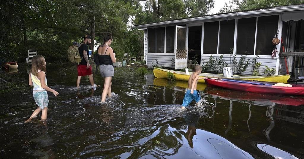
More than 40 trillion gallons of rain drenched the Southeast United States in the last week from Hurricane Helene and a run-of-the-mill rainstorm that sloshed in ahead of it — an unheard of amount of water that has stunned experts.

That’s enough to fill the Dallas Cowboys’ stadium 51,000 times, or Lake Tahoe just once. If it was concentrated just on the state of North Carolina that much water would be 3.5 feet deep (more than 1 meter). It’s enough to fill more than 60 million Olympic-size swimming pools.

“That’s an astronomical amount of precipitation,” said Ed Clark, head of the National Oceanic and Atmospheric Administration’s National Water Center in Tuscaloosa, Alabama. “I have not seen something in my 25 years of working at the weather service that is this geographically large of an extent and the sheer volume of water that fell from the sky.”

The flood damage from the rain is apocalyptic, meteorologists said. More than 100 people are dead, according to officials.

Private meteorologist Ryan Maue, a former NOAA chief scientist, calculated the amount of rain, using precipitation measurements made in 2.5-mile-by-2.5 mile grids as measured by satellites and ground observations. He came up with 40 trillion gallons through Sunday for the eastern United States, with 20 trillion gallons of that hitting just Georgia, Tennessee, the Carolinas and Florida from Hurricane Helene.

Clark did the calculations independently and said the 40 trillion gallon figure (151 trillion liters) is about right and, if anything, conservative. Maue said maybe 1 to 2 trillion more gallons of rain had fallen, much if it in Virginia, since his calculations.

Clark, who spends much of his work on issues of shrinking western water supplies, said to put the amount of rain in perspective, it’s more than twice the combined amount of water stored by two key Colorado River basin reservoirs: Lake Powell and Lake Mead.

Several meteorologists said this was a combination of two, maybe three storm systems. Before Helene struck, rain had fallen heavily for days because a low pressure system had “cut off” from the jet stream — which moves weather systems along west to east — and stalled over the Southeast. That funneled plenty of warm water from the Gulf of Mexico. And a storm that fell just short of named status parked along North Carolina’s Atlantic coast, dumping as much as 20 inches of rain, said North Carolina state climatologist Kathie Dello.

Then add Helene, one of the largest storms in the last couple decades and one that held plenty of rain because it was young and moved fast before it hit the Appalachians, said University of Albany hurricane expert Kristen Corbosiero.

“It was not just a perfect storm, but it was a combination of multiple storms that that led to the enormous amount of rain,” Maue said. “That collected at high elevation, we’re talking 3,000 to 6000 feet. And when you drop trillions of gallons on a mountain, that has to go down.”

The fact that these storms hit the mountains made everything worse, and not just because of runoff. The interaction between the mountains and the storm systems wrings more moisture out of the air, Clark, Maue and Corbosiero said.

North Carolina weather officials said their top measurement total was 31.33 inches in the tiny town of Busick. Mount Mitchell also got more than 2 feet of rainfall.

Before 2017’s Hurricane Harvey, “I said to our colleagues, you know, I never thought in my career that we would measure rainfall in feet,” Clark said. “And after Harvey, Florence, the more isolated events in eastern Kentucky, portions of South Dakota. We’re seeing events year in and year out where we are measuring rainfall in feet.”

Storms are getting wetter as the climate change s, said Corbosiero and Dello. A basic law of physics says the air holds nearly 4% more moisture for every degree Fahrenheit warmer (7% for every degree Celsius) and the world has warmed more than 2 degrees (1.2 degrees Celsius) since pre-industrial times.

Corbosiero said meteorologists are vigorously debating how much of Helene is due to worsening climate change and how much is random.

For Dello, the “fingerprints of climate change” were clear.

“We’ve seen tropical storm impacts in western North Carolina. But these storms are wetter and these storms are warmer. And there would have been a time when a tropical storm would have been heading toward North Carolina and would have caused some rain and some damage, but not apocalyptic destruction. ”

___

Follow AP’s climate coverage at https://apnews.com/hub/climate

___

Follow Seth Borenstein on Twitter at @borenbears

___

Associated Press climate and environmental coverage receives support from several private foundations. See more about AP’s climate initiative here. The AP is solely responsible for all content.

Source link

Continue Reading

Science

‘Big Sam’: Paleontologists unearth giant skull of Pachyrhinosaurus in Alberta

Published

 on


It’s a dinosaur that roamed Alberta’s badlands more than 70 million years ago, sporting a big, bumpy, bony head the size of a baby elephant.

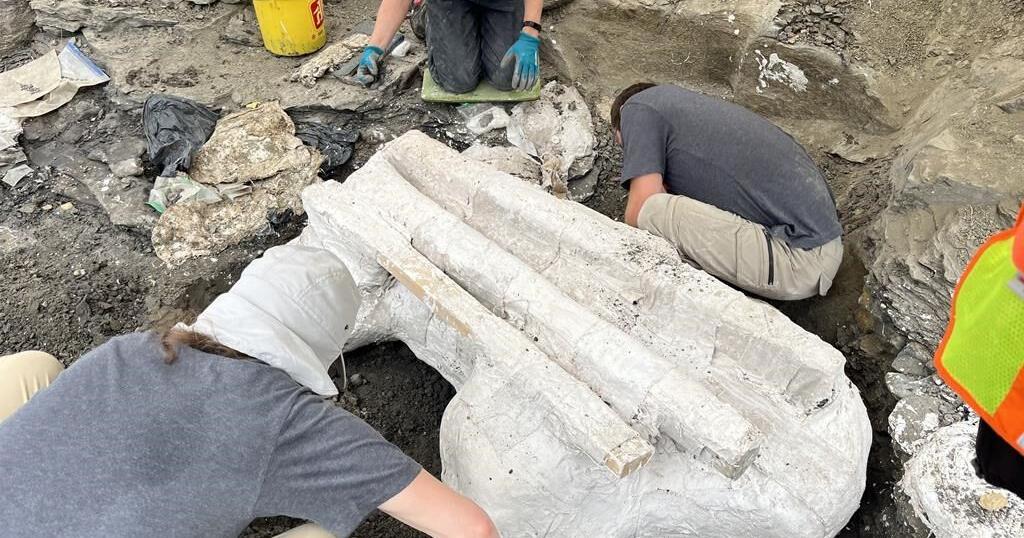
On Wednesday, paleontologists near Grande Prairie pulled its 272-kilogram skull from the ground.

They call it “Big Sam.”

The adult Pachyrhinosaurus is the second plant-eating dinosaur to be unearthed from a dense bonebed belonging to a herd that died together on the edge of a valley that now sits 450 kilometres northwest of Edmonton.

It didn’t die alone.

“We have hundreds of juvenile bones in the bonebed, so we know that there are many babies and some adults among all of the big adults,” Emily Bamforth, a paleontologist with the nearby Philip J. Currie Dinosaur Museum, said in an interview on the way to the dig site.

She described the horned Pachyrhinosaurus as “the smaller, older cousin of the triceratops.”

“This species of dinosaur is endemic to the Grand Prairie area, so it’s found here and nowhere else in the world. They are … kind of about the size of an Indian elephant and a rhino,” she added.

The head alone, she said, is about the size of a baby elephant.

The discovery was a long time coming.

The bonebed was first discovered by a high school teacher out for a walk about 50 years ago. It took the teacher a decade to get anyone from southern Alberta to come to take a look.

“At the time, sort of in the ’70s and ’80s, paleontology in northern Alberta was virtually unknown,” said Bamforth.

When paleontogists eventually got to the site, Bamforth said, they learned “it’s actually one of the densest dinosaur bonebeds in North America.”

“It contains about 100 to 300 bones per square metre,” she said.

Paleontologists have been at the site sporadically ever since, combing through bones belonging to turtles, dinosaurs and lizards. Sixteen years ago, they discovered a large skull of an approximately 30-year-old Pachyrhinosaurus, which is now at the museum.

About a year ago, they found the second adult: Big Sam.

Bamforth said both dinosaurs are believed to have been the elders in the herd.

“Their distinguishing feature is that, instead of having a horn on their nose like a triceratops, they had this big, bony bump called a boss. And they have big, bony bumps over their eyes as well,” she said.

“It makes them look a little strange. It’s the one dinosaur that if you find it, it’s the only possible thing it can be.”

The genders of the two adults are unknown.

Bamforth said the extraction was difficult because Big Sam was intertwined in a cluster of about 300 other bones.

The skull was found upside down, “as if the animal was lying on its back,” but was well preserved, she said.

She said the excavation process involved putting plaster on the skull and wooden planks around if for stability. From there, it was lifted out — very carefully — with a crane, and was to be shipped on a trolley to the museum for study.

“I have extracted skulls in the past. This is probably the biggest one I’ve ever done though,” said Bamforth.

“It’s pretty exciting.”

This report by The Canadian Press was first published Sept. 25, 2024.

The Canadian Press. All rights reserved.

Source link

Continue Reading

News

The ancient jar smashed by a 4-year-old is back on display at an Israeli museum after repair

Published

 on


TEL AVIV, Israel (AP) — A rare Bronze-Era jar accidentally smashed by a 4-year-old visiting a museum was back on display Wednesday after restoration experts were able to carefully piece the artifact back together.

Last month, a family from northern Israel was visiting the museum when their youngest son tipped over the jar, which smashed into pieces.

Alex Geller, the boy’s father, said his son — the youngest of three — is exceptionally curious, and that the moment he heard the crash, “please let that not be my child” was the first thought that raced through his head.

The jar has been on display at the Hecht Museum in Haifa for 35 years. It was one of the only containers of its size and from that period still complete when it was discovered.

The Bronze Age jar is one of many artifacts exhibited out in the open, part of the Hecht Museum’s vision of letting visitors explore history without glass barriers, said Inbal Rivlin, the director of the museum, which is associated with Haifa University in northern Israel.

It was likely used to hold wine or oil, and dates back to between 2200 and 1500 B.C.

Rivlin and the museum decided to turn the moment, which captured international attention, into a teaching moment, inviting the Geller family back for a special visit and hands-on activity to illustrate the restoration process.

Rivlin added that the incident provided a welcome distraction from the ongoing war in Gaza. “Well, he’s just a kid. So I think that somehow it touches the heart of the people in Israel and around the world,“ said Rivlin.

Roee Shafir, a restoration expert at the museum, said the repairs would be fairly simple, as the pieces were from a single, complete jar. Archaeologists often face the more daunting task of sifting through piles of shards from multiple objects and trying to piece them together.

Experts used 3D technology, hi-resolution videos, and special glue to painstakingly reconstruct the large jar.

Less than two weeks after it broke, the jar went back on display at the museum. The gluing process left small hairline cracks, and a few pieces are missing, but the jar’s impressive size remains.

The only noticeable difference in the exhibit was a new sign reading “please don’t touch.”

The Canadian Press. All rights reserved.

Source link

Continue Reading

Trending