Science
Joint NASA, CNES Water-Tracking Satellite Reveals First Stunning Views

|
|
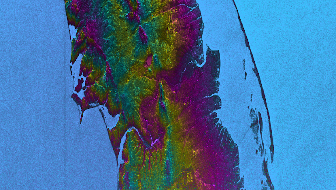
This visualization shows water features on New York’s Long Island – shown as bright pink splotches. Purple, yellow, green, and dark blue shades represent different land elevations, while the surrounding ocean is a lighter blue. The data was collected on Jan. 21, 2023, by SWOT’s KaRIn instrument. Credit: NASA/JPL-Caltech
The Surface Water and Ocean Topography mission offers the first taste of the detailed perspectives of Earth’s surface water that its cutting-edge instruments will be able to capture.
The international Surface Water and Ocean Topography (SWOT) mission – led by NASA and the French space agency Centre National d’Études Spatiales (CNES) – has sent back some of its first glimpses of water on the planet’s surface, showing ocean currents like the Gulf Stream in unprecedented detail. SWOT is also capturing views of freshwater features such as lakes, rivers, and other water bodies down to about 300 feet (100 meters) wide.
The satellite will measure the elevation of nearly all the water on Earth’s surface and provide one of the most comprehensive surveys yet of our planet’s surface water. SWOT’s measurements of freshwater bodies and the ocean will provide insights into how the ocean influences climate change and the water cycle; how a warming world affects water storage in lakes, rivers, and reservoirs; and how communities can better manage their water resources and prepare for floods and other disasters.
“SWOT’s advanced imagery will empower researchers and advance the way we manage fresh water and the effects of sea level rise across the globe,” said NASA Administrator Bill Nelson. “Water is one of our planet’s most important resources – and it’s proven to be vulnerable to the impacts of climate change. SWOT will provide critical information that communities can use to prepare for the impacts of a warming climate.”
A Whole New View
As seen in these early images, on Jan. 21, 2023, SWOT measured sea level in a part of the Gulf Stream off the coast of North Carolina and Virginia. The two antennas of SWOT’s Ka-band Radar Interferometer (KaRIn) instrument acquired data that was mapped as a pair of wide, colored strips spanning a total of 75 miles (120 kilometers) across. Red and orange areas in the images represent sea levels that are higher than the global average, while the shades of blue represent sea levels that are lower than average.
For comparison, the new data is shown alongside sea surface height data taken by space-based instruments called altimeters. The instruments – widely used to measure sea level – also bounce radar signals off of Earth’s surface to collect their measurements. But traditional altimeters are able to look only at a narrow beam of Earth directly beneath them, unlike KaRIn’s two wide-swath strips that observe sea level as a two-dimensional map.
The spatial resolution of SWOT ocean measurements is 10 times greater than the composite of sea surface height data gathered over the same area by seven other satellites: Sentinel-6 Michael Freilich, Jason-3, Sentinel-3A and 3B, Cryosat-2, Altika, and Hai Yang 2B. The composite image was created using information from the Copernicus Marine Service of ESA (European Space Agency) and shows the same day as the SWOT data.
KaRIn also measured the elevation of water features on Long Island – shown as bright pink splotches nestled within the landscape. (Purple, yellow, green, and blue shades represent different land elevations.)
“Our ability to measure freshwater resources on a global scale through satellite data is of prime importance as we seek to adjust to a changing climate,” said CNES Chairman and CEO Philippe Baptiste. “In this respect, the first views from SWOT give us a clearer picture than ever before. These data will prove highly valuable for the international scientific community in the fields of hydrology, oceanography, and coastal studies.”
This initial inland image is a tantalizing indication of how SWOT can measure details of smaller lakes, ponds, and rivers in ways that satellites could not before. Such data will be used to produce an extraordinary accounting of the freshwater on Earth’s surface in ways useful to researchers, policymakers, and water resource managers.
“The KaRIn instrument took years to develop and build, and it will collect information on bodies of water across the globe – data that will be freely and openly available to everybody who needs it,” said Parag Vaze, SWOT project manager at NASA’s Jet Propulsion Laboratory in Southern California.
More About the Mission
Launched on Dec. 16, 2022, from Vandenberg Space Force Base in central California, SWOT is now in a period of commissioning, calibration, and validation. Engineers are checking out the performance of the satellite’s systems and science instruments before the planned start of science operations in summer 2023.
The data for these first images was collected by SWOT’s KaRIn instrument, the scientific heart of the satellite. KaRIn has one antenna at each end of a boom that’s 33 feet (10 meters) long. This enables the instrument to look off to either side of a center line directly below the satellite as it bounces microwave signals off Earth’s surface. The returning radar signals arrive at each antenna slightly out of sync, or phase, from one another. When these signals are combined with other information about the antennas and the satellite’s altitude, scientists will be able to map the height of water on Earth’s surface with never-before-seen clarity. KaRIn encountered an issue earlier this year with one of its subsystems; engineers have now resolved the situation, and the instrument is up and running.
SWOT was jointly developed by NASA and CNES, with contributions from the Canadian Space Agency (CSA) and the UK Space Agency. JPL, which is managed for NASA by Caltech in Pasadena, California, leads the U.S. component of the project. For the flight system payload, NASA provided the KaRIn instrument, a GPS science receiver, a laser retroreflector, a two-beam microwave radiometer, and NASA instrument operations. CNES provided the Doppler Orbitography and Radioposition Integrated by Satellite (DORIS) system, the dual frequency Poseidon altimeter (developed by Thales Alenia Space), the KaRIn radio-frequency subsystem (together with Thales Alenia Space and with support from the UK Space Agency), the satellite platform, and ground operations. CSA provided the KaRIn high-power transmitter assembly. NASA provided the launch vehicle and the agency’s Launch Services Program, based at Kennedy Space Center, managed the associated launch services.


Science
Local astronomer urges the public to look up – Windsor News Today – windsornewstoday.ca


If last week’s solar eclipse piqued your interest in astronomy, the Royal Astronomical Society of Canada’s Windsor Chapter plans to show off some of the more dramatic photos and videos members took of the event.
They were stationed along the path of totality along the northern shore of Lake Erie and in the U.S.
“People did take some nice photos with their cellphones, but we have members who took photos and videos with their telescopes,” said member Tom Sobocan. “You’ll see some pretty impressive shots.”
About 100 members are in the local chapter, which meets every third Tuesday of every month.
Thursday’s meeting is at the Ojibway Nature Centre on Matchette Road. It starts at 7:30, and it’s open to the public. Seating is limited, so Sobocan recommends arriving early.
Astronomers are looking ahead to new wonders in the heavens. Right now, the Pons-Brooks Comet, another once-in-a-lifetime opportunity, is approaching Jupiter in the constellation of Aries.
“If you’re in a dark-sky location, you can see it with the naked eye, and from inside the city, you can see it with binoculars,” said Sobocan. “It may get a little bit brighter going towards the fall, but our members have already photographed it with their telescopes.”
It’s a periodic comet which appears in the night sky once every 71 years.
Sobocan said once-in-a-lifetime events, like last week’s eclipse, inspired many of its existing members, but he hopes some new ones will join the group.
“I hope it inspires them to look up at the sky a little bit more often and realize that everything’s in motion in the sky,” he said. “It’s not stationary.”
Science
Giant, 82-foot lizard fish discovered on UK beach could be largest marine reptile ever found – Livescience.com


Scientists have unearthed the remains of a gigantic, 200 million-year-old sea monster that may be the largest marine reptile ever discovered.
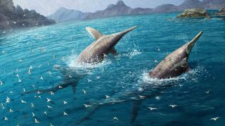
The newfound creature is a member of a group called ichthyosaurs, which were among the dominant sea predators during the Mesozoic era (251.9 million to 66 million years ago). The newly described species lived during the end of the Triassic period (251.9 million to 201.4 million years ago).
Ichthyosaurs had already attained massive sizes by the early portion of the Mesozoic, but it was not until the late Triassic that the largest species emerged.
While the Mesozoic is known as the age of the dinosaurs, ichthyosaurs were not themselves dinosaurs. Instead, they evolved from another group of reptiles. Their evolutionary path closely mirrors that of whales, which evolved from terrestrial mammals that later returned to the sea. And like whales, they breathed air and gave birth to live young.
The newly discovered ichthyosaur species was unearthed in pieces between 2020 and 2022 at Blue Anchor, Somerset in the United Kingdom. The first chunk of the fossil was noticed atop a rock on the beach, indicating that a passerby had found it and set it there for others to examine, the researchers explained in the paper. The researchers published their findings April 17 in the journal PLOS One.
The reptile’s remains are made up of a series of 12 fragments from a surangular bone, which is found in the upper portion of the lower jaw. The researchers estimate the bone was 6.5 feet (2 meters) long and that the living animal was about 82 feet (25 m) long.
The researchers named the sea monster Ichthyotitan severnensis, meaning giant lizard fish of the Severn, after the Severn Estuary where it was found. The team believes it is not only a new species but an entirely new genus of ichthyosaur. More than 100 species are already known.
window.sliceComponents = window.sliceComponents || ;
externalsScriptLoaded.then(() => {
window.reliablePageLoad.then(() => {
var componentContainer = document.querySelector(“#slice-container-newsletterForm-articleInbodyContent-5Tm52KifRnJsTxFt8noX8R”);
if (componentContainer)
var data = “layout”:”inbodyContent”,”header”:”Sign up for the Live Science daily newsletter now”,”tagline”:”Get the worldu2019s most fascinating discoveries delivered straight to your inbox.”,”formFooterText”:”By submitting your information you agree to the Terms & Conditions and Privacy Policy and are aged 16 or over.”,”successMessage”:”body”:”Thank you for signing up. You will receive a confirmation email shortly.”,”failureMessage”:”There was a problem. Please refresh the page and try again.”,”method”:”POST”,”inputs”:[“type”:”hidden”,”name”:”NAME”,”type”:”email”,”name”:”MAIL”,”placeholder”:”Your Email Address”,”required”:true,”type”:”hidden”,”name”:”NEWSLETTER_CODE”,”value”:”XLS-D”,”type”:”hidden”,”name”:”LANG”,”value”:”EN”,”type”:”hidden”,”name”:”SOURCE”,”value”:”60″,”type”:”hidden”,”name”:”COUNTRY”,”type”:”checkbox”,”name”:”CONTACT_OTHER_BRANDS”,”label”:”text”:”Contact me with news and offers from other Future brands”,”type”:”checkbox”,”name”:”CONTACT_PARTNERS”,”label”:”text”:”Receive email from us on behalf of our trusted partners or sponsors”,”type”:”submit”,”value”:”Sign me up”,”required”:true],”endpoint”:”https://newsletter-subscribe.futureplc.com/v2/submission/submit”,”analytics”:[“analyticsType”:”widgetViewed”],”ariaLabels”:;
var triggerHydrate = function()
window.sliceComponents.newsletterForm.hydrate(data, componentContainer);
if (window.lazyObserveElement)
window.lazyObserveElement(componentContainer, triggerHydrate);
else
triggerHydrate();
}).catch(err => console.log(‘Hydration Script has failed for newsletterForm-articleInbodyContent-5Tm52KifRnJsTxFt8noX8R Slice’, err));
}).catch(err => console.log(‘Externals script failed to load’, err));
A number of rib fragments and a coprolite, or fossilized feces, were found in the area as well, but they were not definitively attributed to the same animal.
The sediments in which these specimens were found contained rocks that indicated earthquakes and tsunamis occurred during that time, which suggests that this species lived during a time of intense volcanic activity that may have led to a massive extinction event at the end of the Triassic according to the researchers.
A similar specimen was discovered in Lilstock, Somerset in 2016 and described in 2018. Both were found in what is known at the Westbury Mudstone Formation, within 6 miles (10 kilometers) of each other. This ichthyosaur was estimated to have been as much as 85 feet (26 m) long, although the authors of the latest study believe it was slightly smaller.
The previous contender for the largest marine reptile was another ichthyosaur, Shonisaurus sikanniensis, which was up to 69 feet (21 m) long. S. sikanniensis appeared 13 million years earlier than I. severnensis and was found in British Columbia, making it unlikely that the new discovery represents another specimen of the previously known species.
A similarly massive ichthyosaur called Himalayasaurus tibetensis, which may have reached lengths of 49 feet (15 m), was discovered in Tibet and described in 1972. It dates to the same period, meaning that it probably is not the same species as the new discovery either.
I. severnensis was likely among the last of the giant ichthyosaurs, the researchers claim. Ichthyosaurs persisted into the Cenomanian Age (100.5 million to 93.9 million years ago) of the late Cretaceous period (100.5 million to 66 million years ago). They were eventually supplanted by plesiosaurs — long-necked marine reptiles that went extinct at the end of the Cretaceous, alongside all non-avian dinosaurs.
Science
Federal government announces creation of National Space Council | RCI – Radio-Canada.ca


- Home
- Politics
- Federal Politics
The Canadian Space Agency also received a proposed $8.6 million for its lunar program
Nicole Mortillaro (new window) · CBC News
Canada’s space sector received a boost from the federal government in its budget, both in terms of money and vision.
The 2024 budget (new window) included a proposal for $8.6 million in 2024-25 to the Canadian Space Agency (CSA) for the Lunar Exploration Accelerator Program (new window) (LEAP), which invests in technologies for humanity’s return to the moon and beyond.
In addition to the funding, the federal government also announced the creation of a National Space Council, which will be a new whole-of-government approach to space exploration, technology development, and research.
For Space Canada (new window), an organization comprised of roughly 80 space sector companies including some of Canada’s largest, such as Magellan Aerospace (new window), Maritime Launch (new window) and MDA Space (new window), it was a welcome announcement.
We’ve been advocating for it since the inception of our organization, and we were really very happy, and we applaud the federal government’s commitment announced in the budget,
said Brian Gallant, CEO of Space Canada.
Gallant said that investment in space is an investment in Canada.
Two-thirds of space sector jobs are STEM jobs. These are good paying solid jobs for Canadians. And on top of that, we have approximately $2.8 billion that is injected into the Canadian economy because of the space sector,
he said.
The U.S. formed its National Space Council in 1989, but it was disbanded in 1992 and reestablished in 2017.
In the 2023 budget (new window), the government announced proposed spending of $1.2 billion over 13 years, that was to begin in 2024-25, to the CSA’s contribution of a lunar utility (new window) vehicle that would assist astronauts on the moon. The as–yet–developed vehicle could help astronauts move cargo from landing sites to habitats, perform science investigations or support them during spacewalks on the surface of the moon.
It also proposed to invest $150 million over five years for the LEAP program.
MDA Space, the company behind Canadarm, was also pleased with the announcement.
Canada has an enviable global competitive advantage in space and the creation of a National Space Council is critical to Canada maintaining that leadership position,
CEO Mike Greenley said in an email to CBC News.
Space is now a rapidly growing, highly strategic and competitive domain, and there is a real and urgent need to recognize its importance to the lives of Canadians and to our economy and national security.
The next project for MDA is Canadarm3, which will be part of Lunar Gateway, a international space station that will orbit the moon. It will serve as a sort of jumping-off point for astronauts heading to the moon and eventually beyond.
The Lunar Gateway is a great opportunity for Canada and for MDA Space to not only provide the next generation of Canadarm robotics but to clearly plant our flag as a core national and industry participant in the Artemis era,
Greenley said.
Lunar Gateway is set to begin construction no earlier than 2025 (new window), according to NASA.
-


 Tech20 hours ago
iPhone 15 Pro Desperado Mafia model launched at over ₹6.5 lakh- All details about this luxury iPhone from Caviar – HT Tech
-


 Sports20 hours ago
Lululemon unveils Canada's official Olympic kit for the Paris games – National Post
-


 Science23 hours ago
Astronomers discover Milky Way's heaviest known black hole – Xinhua
-
News18 hours ago
Toronto airport gold heist: Police announce nine arrests – CP24
-
Media22 hours ago
NPR's liberal bias: Editor exposes media's lack of viewpoint diversity – USA TODAY
-


 Tech18 hours ago
Venerable Video App Plex Emerges As FAST Favorite – Forbes
-


 Science24 hours ago
'Almost hit my son' – Space junk crashes through Florida home – BBC.com
-
Investment13 hours ago
Saudi Arabia Highlights Investment Initiatives in Tourism at International Hospitality Investment Forum


