


 Will Study Complex Chemistry On Titan")
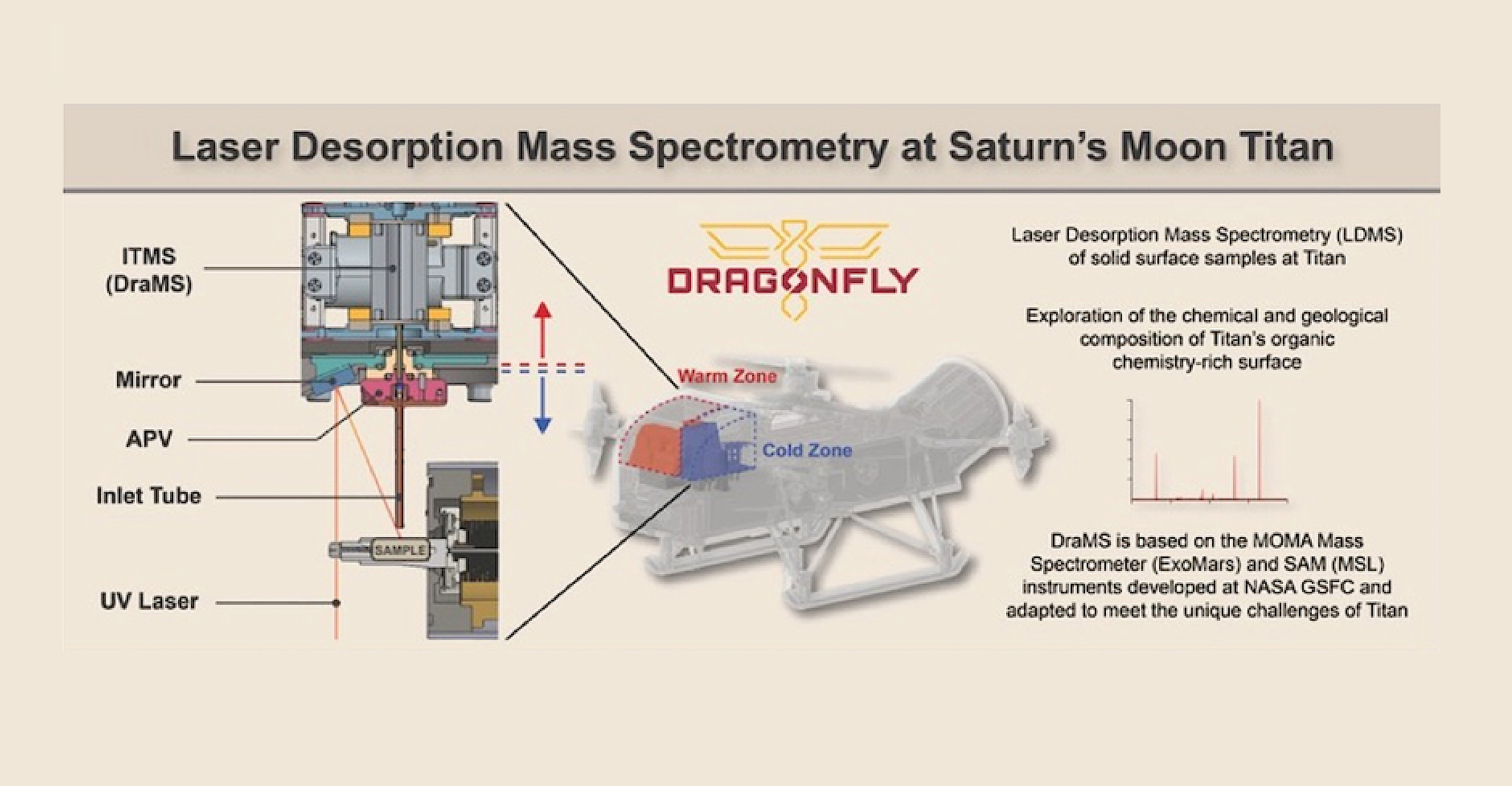
Dragonfly Mass Spectrometer (DraMS)
A new NASA mission to Saturn’s giant moon, Titan, is due to launch in 2027. When it arrives in the mid-2030s, it will begin a journey of discovery that could bring about a new understanding of the development of life in the universe.
This mission, called Dragonfly, will carry an instrument called the Dragonfly Mass Spectrometer (DraMS), designed to help scientists hone in on the chemistry at work on Titan. It may also shed light on the kinds of chemical steps that occurred on Earth that ultimately led to the formation of life, called prebiotic chemistry.
Titan’s abundant complex carbon-rich chemistry, interior ocean, and past presence of liquid water on the surface make it an ideal destination to study prebiotic chemical processes and the potential habitability of an extraterrestrial environment.
Dragonfly Mass Spectrometer (DraMS) – NASA
DraMS will allow scientists back on Earth to remotely study the chemical makeup of the Titanian surface. “We want to know if the type of chemistry that could be important for early pre-biochemical systems on Earth is taking place on Titan,” explains Dr. Melissa Trainer of NASA’s Goddard Space Flight Center, Greenbelt, Maryland.
Trainer is a planetary scientist and astrobiologist who specializes in Titan and is one of the Dragonfly mission’s deputy principal investigators. She is also lead on the DraMS instrument, which will scan through measurements of samples from Titan’s surface material for evidence of prebiotic chemistry.
To accomplish this, the Dragonfly robotic rotorcraft will capitalize on Titan’s low gravity and dense atmosphere to fly between different points of interest on Titan’s surface, spread as far as several miles apart. This allows Dragonfly to relocate its entire suite of instruments to a new site when the previous one has been fully explored, and provides access to samples in environments with a variety of geologic histories.
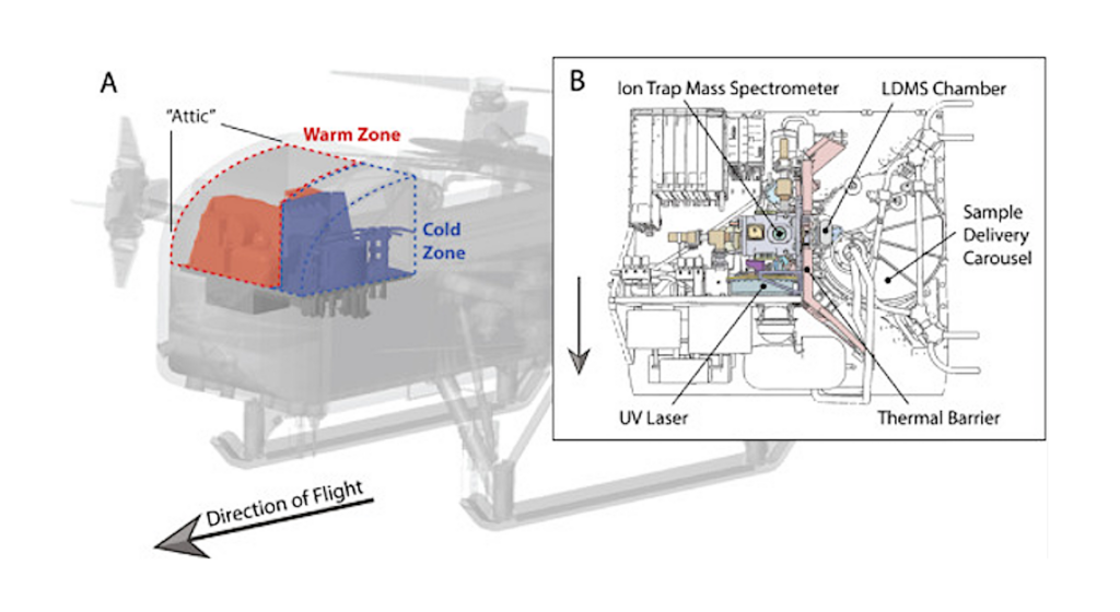
At each site, samples less than a gram in size will be drilled out of the surface by the Drill for Acquisition of Complex Organics (DrACO) and brought inside the lander’s main body, to a place called the “attic” that houses the DraMS instrument. There, they will be irradiated by an onboard laser or vaporized in an oven to be measured by DraMS. A mass spectrometer is an instrument that analyzes the various chemical components of a sample by separating these components down into their base molecules and passing them through sensors for identification.
“DraMS is designed to look at the organic molecules that may be present on Titan, at their composition and distribution in different surface environments,” says Trainer. Organic molecules contain carbon and are used by all known forms of life. They are of interest in understanding the formation of life because they can be created by living and non-living processes.
Mass spectrometers determine what’s in a sample by ionizing the material (that is, bombarding it with energy so that the atoms therein become positively or negatively charged) and examining the chemical composition of the various compounds. This involves determining the relationship between the weight of the molecule and its charge, which serves as a signature for the compound.
DraMS was developed in part by the same team at Goddard which developed the Sample Analysis at Mars (SAM) instrument suite aboard the Curiosity rover. DraMS is designed to survey samples of Titanian surface material in situ, using techniques tested on Mars with the SAM suite.
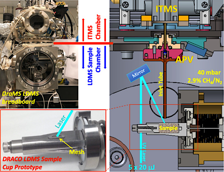
DraMS LDMS prototype setup at GSFC (top left) with the cross-section of the LDMS-relevant region that mimics key aspects of the flight design enlarged (right). DrACO LDMS sample cup prototype used in the testing reported here is shown (bottom left) together with the mesh window through which the ultraviolet laser (typically 5 pulses with 20 μJ pulse energy) interrogates the sample. — NASA
Trainer emphasized the benefits of this heritage. Dragonfly’s scientists did not want to “reinvent the wheel” when it came to searching for organic compounds on Titan, and instead built on established methods which have been applied on Mars and elsewhere. “This design has given us an instrument that’s very flexible, that can adapt to the different types of surface samples,” says Trainer.
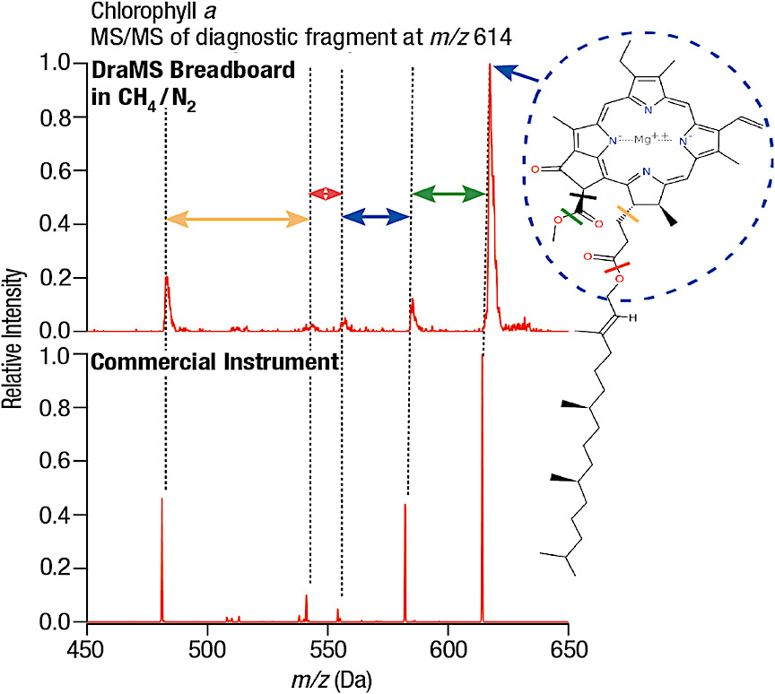
MS/MS fragmentation pattern of the diagnostic fragment peak of Chlorophyll a at m/z = 614 Da obtained on the DraMS breadboard system utilizing 2.9% CH4 in N2 gas mixture (top) and the commercial Thermo MALDI LTQ XLsystem employing Helium as the collision gas (bottom). NASA
DraMS and other science instruments on Dragonfly are being designed and built under the direction of the Johns Hopkins Applied Physics Laboratory in Laurel, Maryland, which manages the mission for NASA and is designing and building the rotorcraft-lander. The team includes key partners at Goddard, the French space agency (CNES, Paris, France), which is providing the Gas Chromatograph Module for DraMS that will provide an additional separation after leaving the oven, Lockheed Martin Space, Littleton, Colorado, NASA Ames Research Center at Moffett Federal Airfield in California’s Silicon Valley, NASA Langley Research Center, Hampton, Virginia, NASA Jet Propulsion Laboratory, Pasadena, California, Penn State University, State College, Pennsylvania, Malin Space Science Systems, San Diego, California, Honeybee Robotics, Brooklyn, New York, the German Aerospace Center (DLR), Cologne, Germany, and the Japan Aerospace Exploration Agency (JAXA), Tokyo, Japan.
Dragonfly is the fourth mission in NASA’s New Frontiers program. New Frontiers is managed by NASA’s Marshall Space Flight Center in Huntsville, Alabama, for the agency’s Science Mission Directorate Washington.
Additional references
Laser Desorption Mass Spectrometry at Saturn’s moon Titan, International Journal of Mass Spectrometry (open access)
Dragonfly Mass Spectrometer Investigation at Titan. COSPAR 2022 Abstract (open access)
Development of the Dragonfly Mass Spectrometer (DraMS) for Titan , LPSC 2021 Abstract (open access)
Selection and Analytical Performances of the Dragonfly Mass Spectrometer Gas Chromatographic Columns to Support the Search for Organic Molecules of Astrobiological Interest on Titan, Astrobiology (paywall)


