Science
As sea levels rise, B.C. coastal cities could face flooding from moon's 'wobble' – Yahoo News Canada
A lunar cycle that happens only once every 18.6 years could combine with rising seas from climate change, and create further problems here on Earth.
What some are calling a “moon wobble” means that B.C.’s coastal communities already bracing for flooding from rising sea levels may also have to contend with an added phenomenon.
“Nothing about the moon is changing, this is a totally predictable effect,” explained Jess McIver, an assistant professor of astronomy at UBC. “It’s been wobbling in this way for millions and millions of years.
“Very, very slowly the axis the moon is orbiting the Earth around is kind of shifting … and the tides are going to respond.”
The issue came to the fore after the release of a new NASA study, published in Nature Climate Change journal earlier this month, “Rapid increases and extreme months in projections of United States high-tide flooding.”
Although the study only examines impacts on U.S. coastal communities, the same effects would apply to cities in B.C. as well as other coastal areas in Canada, explained McIver. She added that the effects of moon wobble would vary by location.
She said she hopes further studies can specifically examine how the phenomenon, known formally as a “precession effect” of the lunar cycle, could impact Canadian tides.
The effect will not become significant until the 2030s, according to NASA, but that’s exactly when rising sea levels are forecast to worsen.
Cities on B.C.’s coast have already begun preparing for rising sea levels, flooding and extreme tides, in addition to the other climate and weather extremes predicted by climate scientists.
And although they have long known oceans will likely encroach on some urban areas, the addition of the lunar “wobble” at almost exactly the same time could amplify the impact.
“We’re going to have this overlap between this very predicted steady creep up in sea level,” McIver said. “And when you combine that with this normal 19-year cadence, all of a sudden we’re going to reach a point where we start seeing this flooding a lot more often.”
The new study is yet another warning to low-lying cities such as Richmond, Delta, Victoria and many First Nations along the coast, said Kees Lokman, chair of landscape architecture at UBC.
Lokman is also principal investigator on a four-year research project, Living With Water, which is examining how cities and First Nations can adapt to climate change and flooding. The project is based out of the University of Victoria’s Pacific Institute for Climate Solutions.
“If we don’t really plan ahead, it will impact us pretty drastically, especially with these new findings,” Lokman said. “Some of these rises to sea level might happen faster than we originally predicted or anticipated.”
The City of Richmond is one municipality that has heavily invested in dikes and flood protections in its climate plan.
The city is built just one metre above sea level, and in 2019 was one of several B.C. municipalities to official declare a climate emergency.
“A considerable amount of upgrades and improvements to the City’s flood protection infrastructure have been completed and are planned for the short-, medium-, and long-term to address infrastructure age, growth and climate change,” Richmond said on its website.
The province’s environment minister, in his most recent mandate letter, was tasked with creating “a coastal strategy to better protect coastal habitat” and protecting the coast’s economy.
Lokman says mitigation of B.C.’s contributions to greenhouse gases should be a priority, but also how communities can adapt to rising sea levels from climate change.
He says effects from the moon wobble could also help communities and policy makers address climate change.
“These events kind of give us a peek into the future of what normal sea level rise might look like,” he said.
Science
West Antarctica's ice sheet was smaller thousands of years ago – here's why this matters today – The Conversation


As the climate warms and Antarctica’s glaciers and ice sheets melt, the resulting rise in sea level has the potential to displace hundreds of millions of people around the world by the end of this century.
A key uncertainty in how much and how fast the seas will rise lies in whether currently “stable” parts of the West Antarctic Ice Sheet can become “unstable”.
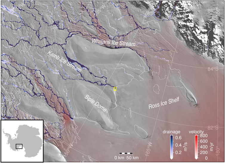
One such region is West Antarctica’s Siple Coast, where rivers of ice flow off the continent and drain into the ocean.
Journal of Geophysical Research, CC BY-SA
This ice flow is slowed down by the Ross Ice Shelf, a floating mass of ice nearly the size of Spain, which holds back the land-based ice. Compared to other ice shelves in West Antarctica, the Ross Ice Shelf has little melting at its base because the ocean below it is very cold.
Although this region has been stable during the past few decades, recent research suggest this was not always the case. Radiocarbon dating of sediments from beneath the ice sheet tells us that it retreated hundreds of kilometres some 7,000 years ago, and then advanced again to its present position within the last 2,000 years.
Figuring out why this happened can help us better predict how the ice sheet will change in the future. In our new research, we test two main hypotheses.
Read more:
What an ocean hidden under Antarctic ice reveals about our planet’s future climate
Testing scenarios
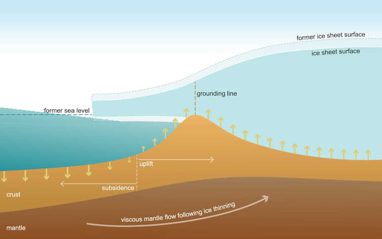
Scientists have considered two possible explanations for this past ice sheet retreat and advance. The first is related to Earth’s crust below the ice sheet.
As an ice sheet shrinks, the change in ice mass causes the Earth’s crust to slowly uplift in response. At the same time, and counterintuitively, the sea level drops near the ice because of a weakening of the gravitational attraction between the ice sheet and the ocean water.
As the ice sheet thinned and retreated since the last ice age, crustal uplift and the fall in sea level in the region may have re-grounded floating ice, causing ice sheet advance.

AGU, CC BY-SA
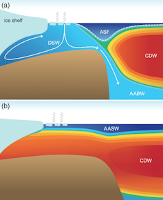
The other hypothesis is that the ice sheet behaviour may be due to changes in the ocean. When the surface of the ocean freezes, forming sea ice, it expels salt into the water layers below. This cold briny water is heavier and mixes deep into the ocean, including under the Ross Ice Shelf. This blocks warm ocean currents from melting the ice.

AGU, CC BY-SA
Seafloor sediments and ice cores tell us that this deep mixing was weaker in the past when the ice sheet was retreating. This means that warm ocean currents may have flowed underneath the ice shelf and melted the ice. Mixing increased when the ice sheet was advancing.
We test these two ideas with computer model simulations of ice sheet flow and Earth’s crustal and sea surface responses to changes in the ice sheet with varying ocean temperature.
Because the rate of crustal uplift depends on the viscosity (stickiness) of the underlying mantle, we ran simulations within ranges estimated for West Antarctica. A stickier mantle means slower crustal uplift as the ice sheet thins.
The simulations that best matched geological records had a stickier mantle and a warmer ocean as the ice sheet retreated. In these simulations, the ice sheet retreats more quickly as the ocean warms.
When the ocean cools, the simulated ice sheet readvances to its present-day position. This means that changes in ocean temperature best explain the past ice sheet behaviour, but the rate of crustal uplift also affects how sensitive the ice sheet is to the ocean.

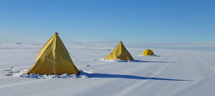
Veronika Meduna, CC BY-SA
What this means for climate policy today
Much attention has been paid to recent studies that show glacial melting may be irreversible in some parts of West Antarctica, such as the Amundsen Sea embayment.
In the context of such studies, policy debates hinge on whether we should focus on adapting to rising seas rather than cutting greenhouse gas emissions. If the ice sheet is already melting, are we too late for mitigation?
Our study suggests it is premature to give up on mitigation.
Global climate models run under high-emissions scenarios show less sea ice formation and deep ocean mixing. This could lead to the same cold-to-warm ocean switch that caused extensive ice sheet retreat thousands of years ago.
For West Antarctica’s Siple Coast, it is better if we prevent this ocean warming from occurring in the first place, which is still possible if we choose a low-emissions future.
Science
NASA's Voyager 1 resumes sending engineering updates to Earth – Phys.org


For the first time since November, NASA’s Voyager 1 spacecraft is returning usable data about the health and status of its onboard engineering systems. The next step is to enable the spacecraft to begin returning science data again. The probe and its twin, Voyager 2, are the only spacecraft to ever fly in interstellar space (the space between stars).
Voyager 1 stopped sending readable science and engineering data back to Earth on Nov. 14, 2023, even though mission controllers could tell the spacecraft was still receiving their commands and otherwise operating normally. In March, the Voyager engineering team at NASA’s Jet Propulsion Laboratory in Southern California confirmed that the issue was tied to one of the spacecraft’s three onboard computers, called the flight data subsystem (FDS). The FDS is responsible for packaging the science and engineering data before it’s sent to Earth.
The team discovered that a single chip responsible for storing a portion of the FDS memory—including some of the FDS computer’s software code—isn’t working. The loss of that code rendered the science and engineering data unusable. Unable to repair the chip, the team decided to place the affected code elsewhere in the FDS memory. But no single location is large enough to hold the section of code in its entirety.
So they devised a plan to divide affected the code into sections and store those sections in different places in the FDS. To make this plan work, they also needed to adjust those code sections to ensure, for example, that they all still function as a whole. Any references to the location of that code in other parts of the FDS memory needed to be updated as well.


The team started by singling out the code responsible for packaging the spacecraft’s engineering data. They sent it to its new location in the FDS memory on April 18. A radio signal takes about 22.5 hours to reach Voyager 1, which is over 15 billion miles (24 billion kilometers) from Earth, and another 22.5 hours for a signal to come back to Earth. When the mission flight team heard back from the spacecraft on April 20, they saw that the modification had worked: For the first time in five months, they have been able to check the health and status of the spacecraft.
During the coming weeks, the team will relocate and adjust the other affected portions of the FDS software. These include the portions that will start returning science data.
Voyager 2 continues to operate normally. Launched over 46 years ago, the twin Voyager spacecraft are the longest-running and most distant spacecraft in history. Before the start of their interstellar exploration, both probes flew by Saturn and Jupiter, and Voyager 2 flew by Uranus and Neptune.
Provided by
NASA
Citation:
NASA’s Voyager 1 resumes sending engineering updates to Earth (2024, April 22)
retrieved 22 April 2024
from https://phys.org/news/2024-04-nasa-voyager-resumes-earth.html
This document is subject to copyright. Apart from any fair dealing for the purpose of private study or research, no
part may be reproduced without the written permission. The content is provided for information purposes only.
Science
Osoyoos commuters invited to celebrate Earth Day with the Leg Day challenge – Oliver/Osoyoos News – Castanet.net


Osoyoos commuters can celebrate Earth Day as the Town joins in on a national commuter challenge known as “Leg Day,” entering a chance to win sustainable transportation prizes.
The challenge, from Earth Day Canada, is to record 10 sustainable commutes taken without a car.
“Cars are one of the biggest contributors to gas emissions in Canada,” reads an Earth Day Canada statement. “That’s why, Earth Day Canada is launching the national Earth Day is Leg Day Challenge.”
So far, over 42.000 people have participated in the Leg Day challenge.
Participants could win an iGo electric bike, public transportation for a year, or a gym membership.
The Town of Osoyoos put out a message Monday promoting joining the national program.
For more information on the Leg Day challenge click here.
-
Business15 hours ago
Honda to build electric vehicles and battery plant in Ontario, sources say – Global News
-


 Science15 hours ago
Will We Know if TRAPPIST-1e has Life? – Universe Today
-
Investment19 hours ago
Down 80%, Is Carnival Stock a Once-in-a-Generation Investment Opportunity?
-


 Health15 hours ago
Simcoe-Muskoka health unit urges residents to get immunized
-


 Health12 hours ago
See how chicken farmers are trying to stop the spread of bird flu – Fox 46 Charlotte
-
News20 hours ago
Honda expected to announce multi-billion dollar deal to assemble EVs in Ontario
-


 Investment13 hours ago
Own a cottage or investment property? Here's how to navigate the new capital gains tax changes – The Globe and Mail
-


 Science21 hours ago
Watch The World’s First Flying Canoe Take Off


